GoBeyondia Atlas 🗺️ East-Asia Oceania 🗾
French Polynesia: Where the ancestors of the Polynesian people crossed the largest ocean on earth in double-hulled canoes navigating by stars, wave patterns, cloud reflections, and the flight paths of birds — no compass, no chart, no sextant — settling more than a thousand scattered islands across a triangle bounded by Hawai’i, New Zealand, and Easter Island, a feat of navigation so precise that in 1965 a researcher sailed from Tahiti to New Zealand using only traditional methods and made landfall with an error of forty-one kilometers after traveling three thousand six hundred — and then between 1966 and 1996 France detonated one hundred and ninety-three nuclear weapons on the atolls of Moruroa and Fangataufa, including devices up to two hundred times the yield of Hiroshima, contaminating the water, the coral, the fish, and the people whose ancestors had found these islands by reading the direction of the swells in the dark — because French Polynesia is the place where the most sophisticated relationship between human beings and the ocean was tested to destruction by a country that could not have found these islands without instruments.
French Polynesia in 30 Seconds
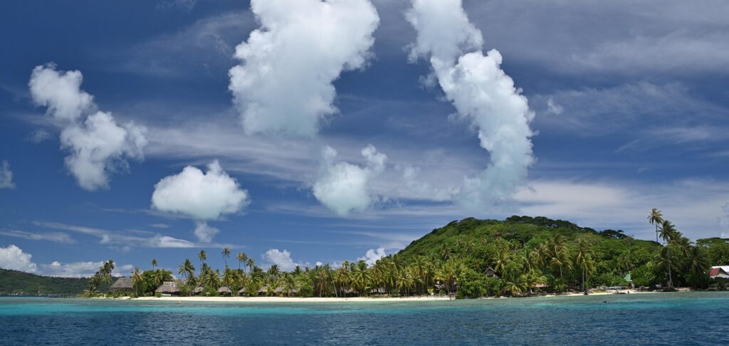
One hundred and eighteen islands and atolls scattered across an area of ocean larger than Western Europe, yet with a total land area smaller than a mid-size European city. Five archipelagoes — the Society Islands, the Tuamotu, the Marquesas, the Gambier, and the Australs — spread across five million square kilometers of the South Pacific. The Polynesian people settled these islands between roughly 700 and 500 BC, arriving from the west in double-hulled voyaging canoes that could carry thirty or more people along with the plants, animals, and seeds needed to establish life on an uninhabited island. They navigated without instruments. Star paths memorized across generations guided them at night — seven to twelve stars were enough for a single voyage, each rising and setting at known points on the horizon. During the day, they read the ocean itself: the spacing of wave crests indicated approaching weather or nearby landmasses; a V-shaped cloud over the horizon meant an island beneath it; a green tint on the underside of a cloud indicated vegetation; a white shimmer indicated a shallow lagoon. Seabirds that flew no farther than thirty nautical miles from land served as living compasses pointing toward shore. The navigators did not use the ocean to reach the islands. They used the islands to read the ocean. In 1768, Captain Cook sailed from Tahiti with a Tahitian navigator named Tupaia aboard his ship, and Tupaia guided Cook three hundred miles south to the island of Rurutu. Cook was astonished to find that Tupaia could always point in the exact direction of Tahiti regardless of their position, without consulting a single chart. Cook never learned how Tupaia did it. Tupaia died of malaria before his methods could be documented. Then, between 1966 and 1996, France conducted one hundred and ninety-three nuclear weapons tests on two atolls in the Tuamotu chain — Moruroa and Fangataufa. Forty-one of these were atmospheric, detonated in the open air until 1974, sending radioactive fallout across the inhabited islands of French Polynesia, including Tahiti. The very first test, codenamed Aldebaran, was a plutonium fission bomb detonated in the lagoon on July 2, 1966. Its radioactive cloud drifted to the island of Mangareva, where the French Overseas Minister was evacuated while local residents were told to shelter indoors. Some of the devices tested were thermonuclear bombs over a hundred times the yield of Hiroshima. Workers at the test sites wore shorts and t-shirts. As of recent reports, Moruroa remains a restricted military zone, still guarded by French forces, still too contaminated to visit. In 2021, President Macron acknowledged that France owed a debt to French Polynesia. He stopped short of a formal apology.
Evoke — Why You Visit French Polynesia
You come to French Polynesia because you have built something — a system, a practice, a way of reading the world — that someone with more power decided to use for their own purpose, and when they were finished, they acknowledged the damage without repairing it. The Polynesian navigators developed the most sophisticated non-instrument navigation system in human history. The word they use is wayfinding — not because they were finding their way, but because they were the way. As one modern navigator, Lehua Kamalu, put it: “We are the compass.” This was not a metaphor. The navigator was the instrument. Everything — the angle of the swell against the hull, the temperature of a current, the behavior of a tern, the color beneath a cloud — was processed through a human being trained from childhood to perceive what the ocean was communicating. This knowledge was transmitted orally, through chants and practice, across generations. It was never written down. It did not need to be. And then France detonated one hundred and ninety-three nuclear weapons in the navigators’ ocean, cracked the coral of Moruroa with a blast that caused a two-kilometer-long fracture, deposited an estimated fifteen kilograms of plutonium into the lagoon sediment, and contaminated the food and water supply of islands whose residents had not been meaningfully informed of the risk. The radioactive fallout from atmospheric tests reached Fiji, Samoa, Tonga, New Zealand, and as far east as Peru. The atolls of the Tuamotu — the very islands that Polynesian navigators once found by reading clouds — became the floor of a weapons program for a European nation that could not have located them without a compass. You come because someone used what you built for a purpose you never intended, and then offered acknowledgment instead of repair. French Polynesia will show you the difference between the two.
Explore — How You Experience French Polynesia
Fly into Papeete on Tahiti, the most populated island, and understand that you are arriving at a place that European cartographers did not map until the eighteenth century but that Polynesian navigators had been sailing to and from for over two thousand years. Travel to the Tuamotu Archipelago — seventy-eight atolls and islands, many barely rising above sea level — and understand that these are the islands navigators detected from the ocean by looking up at the undersides of clouds for lagoon reflections, because the islands themselves were too low to see from any distance. Snorkel in water so transparent that the concept of visibility becomes meaningless — you are not looking through the water, you are in it. If you dive, the coral walls descend into blue darkness, and the biodiversity of these reefs is among the richest in the Pacific. Visit Raiatea, considered the spiritual homeland of Polynesian culture and the island from which the great migratory voyages departed — the place the navigators left from, carrying in their heads the star maps and swell charts that would allow them to cross thousands of kilometers of open ocean and find an island the size of a village. Then sit with the knowledge that approximately four hundred kilometers southeast of where you are standing, two atolls remain off-limits — Moruroa and Fangataufa, still guarded, still contaminated, still holding approximately fifteen kilograms of plutonium in their lagoon sediment, with an estimated ten grams washing into the open ocean every year through underwater cracks. The navigators who found these islands by reading bird flight patterns cannot visit them. The nation that detonated nuclear weapons on them has acknowledged a debt without paying it.
Evolve — Who You Become in French Polynesia
You leave French Polynesia understanding that the most advanced technology is not always the one with the most power. The Polynesian navigators settled a triangle of ocean covering nearly ten million square miles — a feat that required reading, memorizing, and transmitting knowledge of the natural world at a level of precision that modern science is still working to fully understand. When the Polynesian Voyaging Society launched the Hōkūle’a in 1976 to prove that traditional navigation could cross the Pacific, they had to find a master navigator from the Micronesian island of Satawal — a man named Mau Piailug — because the knowledge had nearly been lost in Polynesia itself, eroded not by failure but by the arrival of instruments that made the old skills appear unnecessary. The navigator who revived Polynesian wayfinding was not Polynesian. He was a Micronesian who recognized that the knowledge belonged to the ocean, not to any single island. Today, the Polynesian Voyaging Society aims to train ten million new navigators. The knowledge is being recovered. The atolls are not. You come home and look at the thing you built — the skill, the intuition, the reading of the environment that only you could do — and you understand two things. First: the people with the instruments will always assume they are more advanced than the people without them, and they will always be wrong about that in ways they cannot measure. Second: acknowledgment is not repair. A debt named is not a debt paid. The ocean remembers what was detonated in it. The coral is cracked. The plutonium is still washing out. The navigators are still navigating. And the compass was never a device. It was a person. It always was.
Your practical guide to French Polynesia starts bellow 👇
🕰️ French Polynesia Historical Backdrop
French Polynesia’s history is a legendary saga of oceanic navigation and cultural endurance. Settled by daring Austronesian voyagers around 1500 BC, the islands became the center of a vast Polynesian triangle. For centuries, these master seafarers navigated by the stars, establishing sophisticated societies governed by sacred “marae” (stone temples). European contact in the 18th century brought explorers like Cook and Bougainville, followed by French missionaries and traders. In 1842, the islands became a French protectorate, eventually evolving into an Overseas Collectivity of France. Today, French Polynesia is a vibrant fusion of French chic and Polynesian soul, where the preservation of the Tahitian language, traditional tattooing, and dance is viewed as a vital commitment to the nation’s identity and its legendary maritime legacy.
🌟 French Polynesia Local Experiences
Beyond the luxury resorts, discover the soul of the islands in the communal “Ma’a Tahiti”—a traditional feast cooked in an underground oven (ahima’a) that brings families together every Sunday. Experience the profound stillness of a sunset boat ride through the “Pass” of an atoll, the intoxicating aroma of vanilla curing in the sun on Taha’a, or the simple joy of swimming with wild stingrays and black-tip reef sharks in a shallow sandbar. Whether it’s participating in a traditional flower-weaving workshop or witnessing the high-intensity energy of a “Haka” at the Heiva i Tahiti festival, these moments reveal a nation that finds richness in its connection to the sea and the ancestral power of the land.
🌄 French Polynesia Natural Wonders
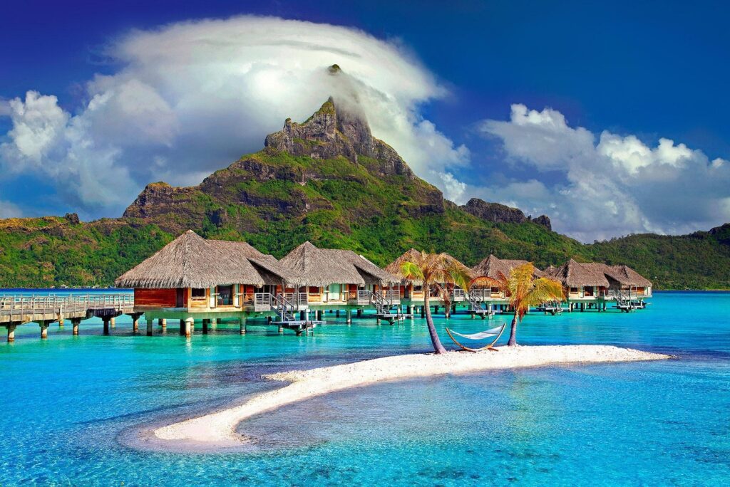
- Mount Otemanu (Bora Bora): An iconic, castle-like volcanic remnant that dominates the world’s most famous lagoon.
- The Blue Lagoon (Rangiroa): A “lagoon within a lagoon,” a pristine pool of brilliant turquoise water surrounded by white-sand islets.
- Faarumai Waterfalls (Tahiti): Three spectacular cascades hidden in a lush tropical valley on the main island.
- Opunohu & Cook’s Bays (Moorea): Two dramatic, mirror-like fjords carved into the northern coast of the “Garden Island.”
- Tiputa Pass: A world-renowned diving site where dolphins leap in the waves and massive schools of sharks gather in the current.
- Mount Rotui: A jagged mountain ridge on Moorea offering one of the most spectacular hiking panoramic views in the South Pacific.
🏙️ French Polynesia Must-See Islands & Regions
- Tahiti: (The Hub) Home to the capital, Papeete, and the international airport, offering vibrant markets, black-sand beaches, and rugged mountain interiors. (Urban, Gateway, Diverse)
- Bora Bora: The “Pearl of the Pacific,” world-famous for its overwater bungalows and its breathtakingly beautiful turquoise lagoon. (Iconic, Romantic, Luxurious)
- Moorea: A lush, heart-shaped island just a short ferry ride from Tahiti, known for its pineapple plantations and jagged peaks. (Adventurous, Scenic, Accessible)
- Rangiroa & Manihi: Part of the Tuamotu atolls, these low-lying rings of coral offer the world’s best diving and pearl farming. (Marine-rich, Remote, Serene)
- Raiatea & Taha’a: The spiritual heartland of Polynesia; Raiatea houses the sacred Marae Taputapuātea, while Taha’a is famous for its world-class vanilla. (Spiritual, Artisanal, Traditional)
🏞️ French Polynesia National Parks & Nature Reserves
Managed with an emphasis on lagoon sustainability by the Direction de l’Environnement (DIREN).
- Marae Taputapuātea: A UNESCO site and a high-yield spiritual landscape on Raiatea.
- Scilly & Mopelia Atolls: Remote biosphere reserves protecting rare sea turtles and pristine coral ecosystems.
- Teahupo’o Biosphere: Protecting the unique coastline and marine environment around the world-famous surf break.
🏛️ UNESCO World Heritage Sites
- Taputapuātea — A political, ceremonial, and social center of the ancient Polynesian world, providing a unique testimony to the millenary civilization of the South Seas.
- For a complete list of natural and cultural initiatives, visit the UNESCO French Polynesia Portal.
🖼️ French Polynesia Museums & Cultural Sites
- Musée de Tahiti et des Îles (Punaauia): The premier institution for Polynesian history, art, and natural science.
- Marae Arahurahu: A beautifully restored ancient open-air temple used for historical re-enactments and ceremonies.
- Robert Wan Pearl Museum (Papeete): Detailing the history and cultivation of the iconic Tahitian Black Pearl.
🎉 French Polynesia Festivals & Celebrations
- Heiva i Tahiti: (July) The most significant cultural festival in the Pacific, featuring high-energy dance competitions, traditional sports, and choral singing.
- Hawaiki Nui Va’a: (October/November) A spectacular three-day outrigger canoe race across the Leeward Islands, representing the ultimate test of human endurance.
- Tahiti Pearl Regatta: (May) A vibrant sailing event celebrating the maritime heritage and the beauty of the lagoons.
🧽 How to Arrive
- ✈️ By Air
- Faa’a International Airport (PPT) in Papeete is the sole international gateway.
- Airlines: Air Tahiti Nui (Flag carrier), Air France, and major carriers (United, Delta, Hawaiian) connect Tahiti to the world.
- Inter-Island: Air Tahiti is the essential regional carrier connecting the various atolls and islands.
- 🚢 By Sea
📶 Stay Connected
- SIM Cards: Major providers are Vini and Vodafone French Polynesia.
- Where to buy: Kiosks are available at Faa’a Airport and in Papeete city center. Passport registration is standard.
- eSIM: Supported by Vini; available via global platforms like Airalo for data.
- Digital Infrastructure: High-speed fiber optics connect major islands, though bandwidth can be limited on remote atolls.
🏨 Where to Stay
French Polynesia offers everything from world-leading luxury overwater resorts to authentic family-run “pensions.”
- The Brando (Tetiaroa): A world-class eco-luxury resort on a private atoll—the pinnacle of sustainability and privacy.
- Four Seasons Resort Bora Bora: The gold standard for overwater luxury and lagoon immersion.
- InterContinental Tahiti Resort & Spa: A classic, high-quality gateway hotel for arrivals and departures.
- Tahitian Guesthouses (Pensions): For an authentic experience, stay with local families on islands like Huahine or Maupiti.
⛳ Unique Finds
- Tahitian Black Pearls: Visit a farm in the Tuamotus to see how “pinctada margaritifera” oysters create these high-margin natural gems.
- Tiaré Gardenia: The national flower; learn how it is used to make the iconic Monoi oil.
- Teahupo’o Wave: Visit the “End of the Road” to witness the power of one of the world’s heaviest surfing waves.
- Traditional Tattoos: Explore the history of Polynesian Tātau, which acted as a visual code for a person’s life and status.
🤝 French Polynesia Cultural Guidance
- The Mana Concept: Respect the local belief in “Mana”—a spiritual force that permeates the islands. Be mindful in sacred marae sites.
- Greetings: A warm “Ia Ora Na” (Hello) and a smile are essential. Islanders are polite and value soft-spoken communication.
- Dress Code: Casual island wear is standard. Beachwear is for the beach; when in Papeete or churches, modest attire is expected.
- Basic Phrases (Tahitian):
- Hello: “Ia Ora Na” (Ee-ah-oh-rah-nah)
- Thank you: “Mauruuru” (Mah-roo-roo)
- Cheers: “Manuia!”
- Everything is good: “Maita’i”
🛂 French Polynesia Entry & Visa Requirements
- EU/Schengen Status: As a French territory, EU citizens can enter with a national ID or passport. US, UK, and Canadian citizens generally do not require a visa for stays up to 90 days.
- Official Source: Consult the Haut-Commissariat de la République en Polynésie française.
💰 Practical Essentials
- Currency: CFP Franc (XPF). It is pegged to the Euro (1 EUR ≈ 119.33 XPF). Cards are accepted in major resorts, but cash is king on local islands and markets.
- Electricity: Type A, B, C, and E. Voltage is 110V/220V. Most modern resorts use standard European or US configurations.
- Safety: One of the safest destinations in the world. Standard urban vigilance is advised in Papeete at night.
- Climate: Tropical. Best visited May to October (Dry Season) to avoid the humid rainy window.
✨ Bonus Tip: The Horizontal Horizon
To truly embrace French Polynesia, you must learn to “Watch the Blue.” Most travelers spend their time looking at the peaks of the islands. Instead, take a day to go to an atoll like Rangiroa where there are no mountains. It is in the absolute, horizontal infinity of a coral ring—where the only boundary is the gradient of blue between the lagoon and the deep ocean—that your own sense of perspective and internal clarity will finally reveal themselves.
🔗 Featured Links
- Official Tourism: Tahiti Tourisme.
- Marine Logistics: Air Tahiti (Regional).

Beyondia
Trusted Travel CompanionReal digital nomad. I travel. I learn. I grow.
What about you? Where are you going?