🌐 Around the World with Beyondia 🧵 Nordic & Western Europe Region 🪡 Episode 53: Lagos
Between 1418 and 1460, a small Portuguese port on the southern Algarve coast served as the operational base for a systematic project of Atlantic exploration that produced, across four decades, the first coherent European maps of the African coast, the Cape Verde islands, the equator crossing, and eventually the sea route to India. The intellectual centre was thirty-two kilometres west at Sagres, where Prince Henry the Navigator coordinated cartographers, navigators, and shipbuilders. The operational port was here, at Lagos, where caravels were built, provisioned, and dispatched. Christopher Columbus learned his navigation in Portugal in the 1470s and 1480s, taught by veterans of this exploration project. Vasco da Gama sailed for India from the same coast in 1497. Every subsequent European mapping of the world traces operationally to this small town, which mapped the entire planet — and, uncomfortably, invented the transatlantic slave trade in the same decades, in the same square, using the same commercial infrastructure.
Lagos is a small port town on the southern Algarve coast of Portugal
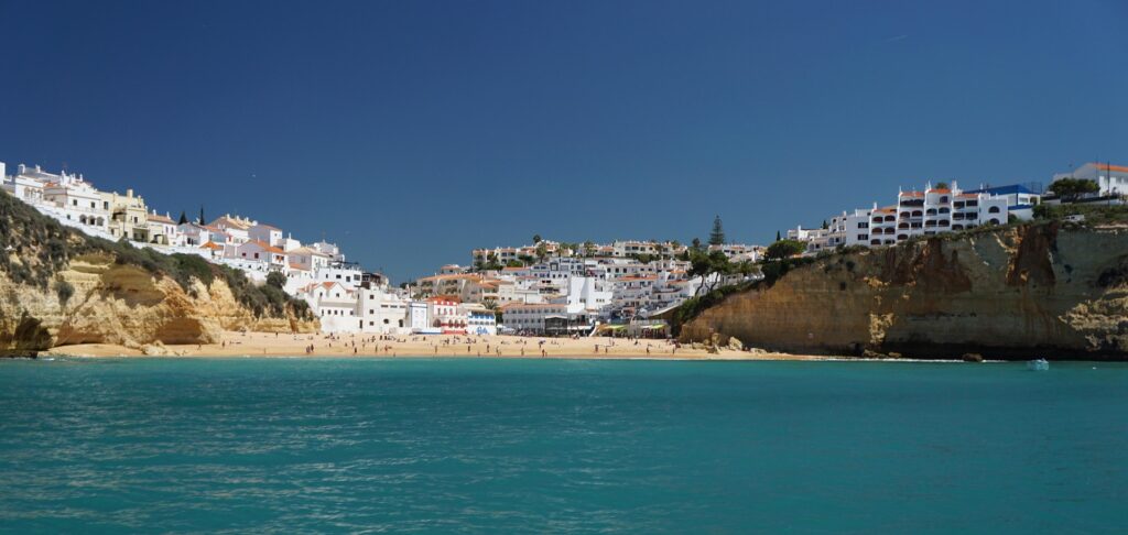
Population approximately 32,000, sitting on a natural harbour formed by the Ribeira de Bensafrim river estuary and the Atlantic coast, approximately 85 kilometres west of Faro (the Algarve regional capital) and approximately 260 kilometres south of Lisbon. It is one of the smaller major towns of the Algarve — smaller than Faro, Portimão, or Albufeira — and its contemporary economy is dominated by beach-and-culture tourism, receiving approximately 1.5 million visitors per year. The town has a compact walkable medieval old city partially enclosed by preserved 15th-century walls, dramatic Atlantic cliffs immediately to the southwest at the Ponta da Piedade promontory, and 4 kilometres of golden-sand beach at Meia Praia to the east. This is what a first-time visitor sees. It is not what makes Lagos genuinely significant.
What makes Lagos significant is that this small port served, for approximately four decades in the 15th century, as the operational base for one of the most consequential single projects in the history of European engagement with the world. Between roughly 1418 and 1460, Prince Henry the Navigator — Infante Dom Henrique, third son of King João I of Portugal, born 1394, died 1460, and one of the more consequential single institutional-builders in early modern European history — coordinated the systematic Portuguese exploration of the West African Atlantic coast from the southern Algarve. The intellectual centre of the project was at Sagres, on the Cape St Vincent promontory 32 kilometres west of Lagos, where Henry established what tradition calls a Escola de Sagres (the Sagres School) — an informal but sustained gathering of cartographers, navigators, shipbuilders, astronomers, and mathematicians who worked together to solve the specific technical problems of Atlantic maritime exploration. The operational port of the project was here at Lagos, where caravels were built by Portuguese shipwrights, provisioned by Portuguese merchants, and dispatched into the Atlantic with the systematic backing of Henry’s court investment.
The scope of what this small coordinated project actually accomplished across four decades is genuinely difficult to overstate. In 1418-1419, Portuguese caravels sighted Madeira (treated in the previous Ep 52 article). By the mid-1420s, systematic voyaging down the African coast had begun. In 1434, Gil Eanes rounded Cape Bojador on the Western Saharan coast — a crossing that had been considered mythologically impossible in medieval European geography, since Ptolemaic and Arab-influenced traditions held that beyond Cape Bojador lay unnavigable waters, monsters, and boiling seas. The crossing was accomplished by systematic patient application of the specific navigational techniques developed at Sagres — sailing westward from the coast in wide loops to catch the Atlantic westerlies that would carry the caravel back around the cape, rather than attempting to sail directly along the coast against the prevailing wind and current. In 1444, Portuguese voyages reached the Senegal River. In 1456, Cape Verde islands were claimed. In 1462, Sierra Leone. In 1471, the Gulf of Guinea. In 1473, the equator was crossed. In 1488, Bartolomeu Dias rounded the Cape of Good Hope. In 1497-1498, Vasco da Gama sailed from Lisbon south along the same Atlantic route, around the Cape of Good Hope, and across the Indian Ocean to Calicut on the Malabar coast of India — completing the sea-route project that Henry had begun 80 years earlier. Every one of these voyages traced operationally to the exploration infrastructure Henry had assembled at Sagres and Lagos in the 1420s to 1460s. The Portuguese padrão real (the master world chart, updated continuously from the reports of returning voyages) became the most authoritative single cartographic document of the western Mediterranean by the mid-15th century, and its lineage flows directly through the subsequent Portuguese-Spanish-Italian cartographic tradition into the modern global map.
The technical innovations of the Sagres-Lagos
The technical innovations of the Sagres-Lagos project are also worth naming. The Portuguese caravel — a small, manoeuvrable ship with a distinctive lateen sail rig that allowed it to sail closer to the wind than any previous European ship design — was developed and refined at the Portuguese shipyards, including those at Lagos, across the 1420s and 1430s. It became the standard ship of Atlantic exploration and remained so through the following century. The astrolabe and the quadrant, medieval Islamic astronomical instruments adapted for maritime use by the Sagres school, allowed navigators to determine latitude at sea by measuring the altitude of Polaris or the noon sun — the first reliable non-coastal navigation techniques available to Atlantic sailors. The systematic Portuguese charts of the African coast, produced from the reports of Henry’s expeditions, provided the first coherent European geographic understanding of the western African coastline that had been essentially unknown to European cartography before the 1420s. Christopher Columbus, who lived in Portugal from 1476 to 1485, learned Atlantic navigation directly from veterans of the Sagres-Lagos project — including his own father-in-law, Bartolomeu Perestrelo, who had participated in the Portuguese colonisation of Porto Santo (the smaller of the Madeira islands). When Columbus sailed for the Spanish crown in 1492, he was applying navigational techniques and geographic knowledge developed in Portugal by the Sagres school across the previous seven decades. The Portuguese role in Columbus’s education is one of the more consequential and least-recognised cross-national threads in early modern European history. The article installs it explicitly.
And in the same decades, in the same square in Lagos, using the same commercial infrastructure, the Portuguese exploration project also inaugurated the transatlantic trade in enslaved Africans. This is the article’s hardest single claim, and it must be handled with tonal discipline. In 1444, on the Praça da República in Lagos — then called the Terreiro do Alface — a public auction was held of approximately 235 people captured from the Mauritanian and Senegalese Atlantic coast by Portuguese caravels of the Henry-coordinated exploration project. The auction is documented in detail in the Crónica dos Feitos da Guiné — the chronicle of Portuguese exploration written by Gomes Eanes de Zurara, Henry’s court chronicler, and completed in the 1450s. Zurara’s chronicle is one of the most disturbing single documents in the historical record of European engagement with Africa: it describes the auction in explicit detail, records the sorting of families and the separation of parents from children as “sad and pitiful,” notes that Henry himself was present and received his royal share of the captives (approximately 46 individuals), and — Zurara’s most disturbing passage — attempts to justify the auction as a religious act of Christian conversion. The chronicle is now available in modern editions and is used in Portuguese university history courses as one of the primary documents of the origins of the transatlantic slave trade.
The 1444 auction was not the first Portuguese capture of Africans — smaller earlier captures had taken place from the late 1430s onwards — but it was the first documented public commercial auction, and it established the institutional template that would be replicated across the following four centuries. The legal framework (Portuguese royal law recognised the captives as commercial property), the commercial procedures (public auction with royal share), the financial infrastructure (Lagos merchants as buyers and Lisbon shipping as distribution), and the destination system (Madeira sugar plantations, and eventually Brazilian and Caribbean plantations from the 16th century onwards) — all of these were operational at Lagos in the 1440s. The 12.5 million people transported across the Atlantic in slavery over the following four centuries were transported through commercial and legal systems that traced operationally to the Praça da República in Lagos in 1444.
The Mercado de Escravos building — a small stone customs house dating to the 15th century, still standing on the Praça da República — sits on the site of the original 1444 auction. Since 2016, it has operated as a museum specifically dedicated to the European origins of Atlantic slavery, one of the very few such museums anywhere in the world located at the actual historical site of the events it documents. The museum is small, modestly curated, and honest — it names the 1444 auction, cites Zurara’s chronicle, and acknowledges the Portuguese institutional role in the origins of the transatlantic slave trade. It is one of the more courageous pieces of contemporary Portuguese public history. The town’s simultaneous role as the operational birthplace of European systematic global mapping and as the operational birthplace of the transatlantic slave trade is not a coincidence or a contradiction — it reflects the fact that the same commercial and navigational infrastructure that produced the geographic knowledge also produced the commercial slavery. Both facts are true simultaneously. The article, following the same tonal discipline established across the Bordeaux, Seville, Casablanca, Rabat, and Madeira articles, names both and refuses to moralise or omit either.
The physical inheritance of the 15th-century exploration project remains partially legible in Lagos today. The old town within the preserved medieval walls contains the Governor’s Castle (the residence of the town’s Portuguese royal governor during the exploration decades, partially preserved), the Igreja de Santa Maria (the church where returning navigators traditionally gave thanks, dating to the 15th century in its foundations), and the Mercado de Escravos building on the Praça da República. The Ponta da Bandeira Fortress, at the harbour mouth, was built in the 17th century to defend the harbour that Henry’s caravels had used — its lookout tower commands the same Atlantic horizon that the exploration voyages sailed toward. The Igreja de Santo António — an 18th-century church with one of the most elaborate gilt-wood interior decorations in the Algarve — is one of the finest Rococo interiors in southern Portugal, though it postdates the Henry-era exploration project by three centuries. The Mercado Municipal (built 1924 in a distinctive Portuguese blue-and-white ceramic-panel style) still functions as a working fish and produce market.
Immediately southwest of the town, the Ponta da Piedade promontory rises approximately 20 metres above the Atlantic, its limestone cliffs carved by wave action across millennia into a landscape of arches, sea-caves, grottos, and sea-stacks in varied ochre, amber, and gold. The Ponta da Piedade is one of the most photographed Atlantic coastal formations in southern Europe, and small motor-launches from Lagos harbour offer boat trips through the sea-caves that are one of the most-photographed tourist experiences in Portugal. The nearby beaches — Praia Dona Ana and Praia do Camilo, tucked beneath the cliffs — are protected small coves accessed by long staircases from the clifftop, and are among the most visually distinctive beaches in Portugal. The 4-kilometre Meia Praia beach east of the harbour, in contrast, is a broad open Atlantic beach with the same golden sand and the traditional fishing-village-turned-tourism-strip character that the Algarve is generally known for.
The contemporary Lagos economy is dominated by tourism
The contemporary Lagos economy is dominated by tourism, and the town’s very modern tourism-town character stands in sometimes-uncomfortable juxtaposition with its extraordinary historical significance. The old town in high summer is crowded with British, German, Dutch, and Scandinavian visitors; the Meia Praia beach clubs and restaurants are full through the July-August peak; the Ponta da Piedade boat trips depart every 30 minutes from 9 AM to sunset. The historical museums — the Mercado de Escravos, the small Municipal Museum, the Governor’s Castle exhibitions — are visited by a small fraction of the total tourism traffic. Most visitors come for the beaches, the seafood, the Atlantic coastal drama, and the walkable old town. Some come for the historical significance. Both patterns of visitation are legitimate. The town’s role in the history of European exploration and the transatlantic slave trade will not diminish because most beach visitors do not know about it — the historical significance is a fact independent of contemporary recognition — but the article’s job is to make it visible to any reader who wants to see it.
The traditional cuisine of Lagos emphasises Atlantic seafood: grilled sardines (sardinhas assadas) in charcoal-grilled form, the classic Portuguese cataplana de marisco (a shellfish stew cooked in a distinctive hinged copper pot that gives the dish its name), arroz de marisco (Atlantic rice-and-seafood in the Portuguese-Algarve style, cooked with heavy tomato and coriander), grilled octopus, and carne de porco à alentejana (pork with clams — the classic Alentejo-Algarve dish that combines the interior mountain agriculture with the coast). The dessert tradition draws on the Algarve interior — almond, fig, and honey pastries reflecting the region’s traditional agriculture, with dom rodrigo (sweet egg-and-almond dessert), morgado de figo (fig and almond marzipan), and tarte de alfarroba (carob tart) as characteristic examples. Portuguese white wine — particularly the crisp Vinho Verde from the north and the Alentejo wines from the interior — is the standard pairing.
This is the deeper character of Lagos, and the article proposes to close on it. The town is one of the smaller major towns of the Portuguese Algarve, with dramatic Atlantic cliffs, golden beaches, a preserved medieval old city, and a contemporary economy dominated by tourism. It was also, for approximately four decades in the 15th century, the operational port of the Portuguese Atlantic exploration project coordinated by Prince Henry the Navigator from Sagres — a project whose systematic voyaging produced the first coherent European maps of the African coast, provided the operational template for the subsequent Spanish, English, French, and Dutch Atlantic empires, and trained the generation of navigators (including Christopher Columbus) who would map the Atlantic world across the following century. It was simultaneously the site of the 1444 auction that inaugurated the transatlantic trade in enslaved Africans, establishing the commercial template that would transport approximately 12.5 million people across the Atlantic in slavery over the following four centuries. Both facts are true and both are documented. The town’s Mercado de Escravos museum has, since 2016, acknowledged the second fact openly. The town’s other museums, the walking tours, and the tourism marketing acknowledge the first. Both fit uncomfortably alongside the beach clubs, the cliff photography, and the seafood restaurants of the contemporary Algarve. The historical significance does not diminish the contemporary tourism appeal. The contemporary tourism does not erase the historical significance. The town contains both, six hundred years apart, on the same square kilometre of Atlantic coast.
Some ports served their own local hinterlands. This one served the systematic mapping of the entire planet — and, in the same decades, in the same square, using the same commercial infrastructure, invented the transatlantic slave trade whose consequences shaped four continents across the following four hundred years.
Nine regions. One hundred and twenty destinations. Three hundred and eight weeks remaining.
The journey continues north. The next stop is Portugal’s capital — a city built on seven hills, destroyed by an earthquake in 1755 that changed European philosophy, and rebuilt in a grid pattern that predated Barcelona’s by a century.

Beyondia
Trusted Travel CompanionReal digital nomad. I travel. I learn. I grow.
What about you? Where are you going?