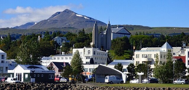
🌐 Around the World with Beyondia 🧵 Nordic & Western Europe Region 🪡 Episode 69: Akureyri
Akureyri is the second-largest urban area in Iceland, sitting at the head of Eyjafjörður on the northern coast of the country. The population is approximately 20,000 — a fraction of Reykjavík’s 140,000 but substantial for a country of 400,000 total residents, and enough to sustain a genuine second urban centre with its own university, hospital, cultural institutions, and distinct identity. The town is 380 kilometres north of Reykjavík by road (approximately 5 hours drive along Route 1, the Ring Road that circles Iceland) or 45 minutes by air. It sits at 65 degrees 41 minutes north latitude, roughly 100 kilometres south of the Arctic Circle at 66 degrees 33 minutes north. This makes Akureyri one of the northernmost cities in the world with a population over 15,000 — comparable in latitude only to Tromsø in Norway, Murmansk in Russia, and a handful of northern Canadian and Alaskan settlements. Fairbanks, Alaska sits at approximately the same latitude.
The Northern Lights are Visible from Akureyri
The extreme northern position produces the daylight variation characteristic of subarctic latitudes. Midsummer brings approximately 21 hours of daylight from mid-June to mid-July, with the sun setting briefly around midnight before rising again around 2 AM — not the true midnight sun (which requires locations north of the Arctic Circle) but close enough that darkness is minimal for approximately three weeks. Midwinter brings approximately 4 hours of usable daylight in late December, with the sun rising around 11 AM and setting around 3 PM. The Northern Lights are visible from Akureyri during clear winter nights between approximately September and April, providing substantial tourism draw.
The paradox is that despite the extreme northern latitude, Akureyri has a comparatively mild subarctic climate rather than an Arctic one. The specific factors are the fjord geography and the ocean influence. Eyjafjörður is Iceland’s longest fjord at approximately 60 kilometres, cutting deeply into the northern coast between substantial mountains. The mountains on both sides rise to 1,000-1,500 metres, providing substantial shelter from the Arctic winds that would otherwise sweep across the northern Icelandic coast. The fjord itself, warmed by the North Atlantic Current (a continuation of the Gulf Stream), moderates temperatures throughout the year. Winter temperatures at Akureyri average approximately -2°C in January (mild for the latitude), summer temperatures average approximately 11°C in July with peak days reaching 20-25°C. Snow falls substantially through winter (approximately 130 days per year with snow cover) but temperatures rarely reach the extreme cold experienced at similar latitudes in Siberia or continental North America.
The consequence is that Akureyri supports agricultural and horticultural activity that would be impossible at similar latitudes elsewhere. The Akureyri Botanical Garden (Lystigarður Akureyrar) — established 1912, expanded across the 20th century — is one of the northernmost botanical gardens on Earth, and one of the most substantially stocked. The garden covers approximately 3.6 hectares and contains over 7,000 plant species from around the world, including species from tropical regions grown in outdoor gardens through the summer months. The specific microclimate produced by the fjord shelter, combined with the substantial summer daylight (approximately 21 hours in midsummer), allows plants from temperate and warm-temperate regions to thrive during the growing season. Alpine plants, Arctic plants, and various flowering species from mountainous regions worldwide are permanently established in the garden. Tropical plants including hibiscus, gladioli, and dahlias are grown in outdoor plantings during summer and moved to greenhouses for winter. The garden is open free of charge from June through September and receives approximately 90,000 visitors per year. It is one of Akureyri’s substantial cultural institutions and one of the botanical achievements that most demonstrates the specific paradox of the region.
The town itself grew from a substantial Danish trading post established in 1602 during the Danish trade monopoly period (covered at Reykjavík Ep 67 and Westfjords Ep 68). Akureyri was one of six Danish trading monopoly stations distributed around Iceland, and the Eyjafjörður location provided substantial harbour access for both fishing and trade. Following the abolition of the Danish trade monopoly in 1787, Akureyri developed as a substantial independent commercial centre. Municipal town status was granted in 1862. The 19th-century wooden buildings that survive from this period are concentrated in the Innbær (“Inner Town”) district near the harbour — approximately 30 preserved wooden buildings dating from the 1830s to the 1890s, providing substantial specific evidence of 19th-century Icelandic urban architecture. These buildings include the Nonnahús (the childhood home of Icelandic children’s author Jón Sveinsson, 1857-1944, who wrote the Nonni books popular across German-speaking Europe in the early 20th century), the Laxdalshús (the oldest surviving wooden house in Akureyri, built 1795), and the Matthíasarhús (home of the poet Matthías Jochumsson, 1835-1920, who wrote the Icelandic national anthem in 1874).
Akureyri’s growth
Akureyri’s growth accelerated in the 20th century as Iceland modernised. From approximately 1,100 residents in 1901 to approximately 8,000 by 1960 to approximately 15,000 by 1990 to approximately 20,000 today. The town developed substantial fishing industry infrastructure, substantial manufacturing (particularly food processing and shipbuilding), and substantial service sector employment. The University of Akureyri (established 1987) has approximately 2,500 students and provides specific specialisations including marine biology, fisheries science, health sciences, and law. Sjúkrahúsið á Akureyri (Akureyri Hospital) serves as the regional hospital for northern Iceland with approximately 1,000 employees and 200 beds. Akureyri Airport provides domestic connections to Reykjavík (multiple daily flights) and increasing international connections, particularly to European destinations for winter tourism.
The Akureyrarkirkja (Akureyri Church) — the substantial Lutheran parish church that dominates the town skyline from its hillside position above the harbour — is one of the substantial 20th-century Icelandic churches. Designed by state architect Guðjón Samúelsson (the same architect who designed Hallgrímskirkja in Reykjavík) and completed 1940, the church reflects a distinctive Icelandic architectural language combining classical proportions with basaltic columnar geometry inspired by Icelandic geological formations. The church contains substantial specific features including a 1928 organ, elaborate stained glass windows (some panels rescued from Coventry Cathedral in England, England after the November 1940 German bombing that destroyed the medieval cathedral — the panels had been removed and stored for safety, and one specific window was subsequently sent to Iceland), and a suspended ship model that represents a traditional Icelandic religious symbol of divine protection for seafarers. The 111 steps leading up to the church from the town centre are one of the substantial Akureyri walking experiences.
Beyond Akureyri
Beyond Akureyri itself, the town serves as the gateway to substantial northern Icelandic natural attractions. The Diamond Circle — the substantial northern equivalent of the Golden Circle route from Reykjavík — connects several major landmarks in a 250-kilometre loop from Akureyri. Goðafoss (“Waterfall of the Gods”) sits approximately 45 kilometres east of Akureyri on the Skjálfandafljót river, cascading approximately 12 metres in a horseshoe shape approximately 30 metres wide. The name refers to a specific historical event: in 1000 AD, when the Althing formally adopted Christianity as Iceland’s state religion (covered at Reykjavík Ep 67), the lawspeaker Þorgeir Ljósvetningagoði — who had made the decision — returned to his farm at Ljósavatn near Goðafoss and threw his statues of the Norse gods into the waterfall as a symbolic renunciation of paganism. The name Goðafoss (literally “waterfall of the gods”) reflects this event. The waterfall is one of Iceland’s most photographed and is easily accessible from Route 1.
Lake Mývatn (approximately 90 kilometres east of Akureyri) is a substantial shallow lake covering approximately 37 square kilometres surrounded by one of Iceland’s most geologically active volcanic regions. The lake and its surroundings contain substantial specific features: pseudocraters at Skútustaðir (crater-shaped formations produced by steam explosions when lava flowed over wet ground, not by direct volcanic eruption), the Dimmuborgir lava field (“dark castles” — a substantial specific area of dramatic lava formations produced by a large lava flow approximately 2,300 years ago), Hverfjall (a substantial specific tephra cone volcano approximately 420 metres high with a specific 1-kilometre-diameter crater), the Krafla geothermal area (with the substantial Víti crater lake and active geothermal power station), and substantial specific bird populations (Mývatn is one of Europe’s most substantial breeding grounds for waterfowl, with 15 species of duck breeding on the lake — one of the highest concentrations in the world). The Mývatn Nature Baths — a geothermal spa opened 2004, sometimes described as the northern equivalent of the Blue Lagoon — provide substantial specific therapeutic bathing in geothermal water at approximately 36-40°C.
Dettifoss (approximately 130 kilometres east of Akureyri) is one of Europe’s most powerful waterfalls by volume. Located on the Jökulsá á Fjöllum river (Iceland’s second-longest river), Dettifoss cascades approximately 45 metres over a 100-metre-wide edge. Peak summer water flow reaches approximately 500 cubic metres per second, making Dettifoss substantially more powerful in terms of raw volume than any waterfall in continental Europe. The waterfall was famously featured in the opening sequence of Ridley Scott’s 2012 film Prometheus.
Húsavík (approximately 90 kilometres northeast of Akureyri) is the whale-watching capital of Iceland, sitting on Skjálfandi Bay — one of the world’s best whale-watching locations. Twenty-three whale species have been documented in the bay, though eight species are regularly observed on tour boats: minke whales (the most commonly seen), humpback whales (with substantial specific individuals returning annually and identified by fluke patterns), blue whales (the largest animal to have ever existed on Earth, occasionally observed in Skjálfandi Bay particularly in spring), fin whales, orcas, white-beaked dolphins, harbour porpoises, and long-finned pilot whales. The whale-watching season runs April through October, with peak activity June through August. Multiple whale-watching companies operate from Húsavík harbour, and the specific companies collaborate through a citizen science project (Whale Wise) that documents individual whale sightings and provides substantial research contribution to whale conservation. Húsavík also contains the Húsavík Whale Museum (established 1997), which provides substantial specific educational content on whale biology, whaling history, and conservation. The town of approximately 2,300 residents itself has substantial character — a working fishing port with wooden buildings, a distinctive wooden church (Húsavíkurkirkja, completed 1907), and the specific position as one of Iceland’s substantial specific rural cultural centres.
Contemporary Akureyri combines these elements — substantial northern urban centre, gateway to major natural attractions, working fishing and manufacturing town, university and hospital centre, botanical achievement — with substantial specific challenges. The tourism boom of the 2010s substantially transformed Akureyri as it did Reykjavík, with substantial specific hotel development, restaurant expansion, and international visitor traffic. Approximately 240,000 international visitors reach Akureyri annually, substantially fewer than the approximately 2 million who reach Reykjavík but growing rapidly. The specific tension between rural character preservation and tourism development is one of the ongoing negotiations, similar to those documented at Westfjords Ep 68 but at substantially larger scale. Housing pressure has developed. Restaurant scenes have expanded. The specific character of Akureyri as Iceland’s counter-capital has been substantially reinforced by the tourism boom rather than diluted — the town has retained its distinct identity while benefiting from expanded economic opportunity.
Akureyri is one of the demonstrations that geography and climate are not the same thing. At 65 degrees 41 minutes north, closer to the Arctic Circle than most of Alaska’s populated areas, the town supports a botanical garden containing tropical plants, agricultural production of substantial variety, urban infrastructure comparable to substantially southern Icelandic cities, and a quality of life that most residents describe as substantially preferable to Reykjavík’s larger scale. The fjord shelters the town from Arctic winds. The ocean current warms the winter. The mountains provide the specific dramatic setting that makes Akureyri visually one of Iceland’s substantial urban destinations. The community of 20,000 people has built the substantial northern city that most foreign visitors do not know exists — the alternative Iceland to the mass-tourism Golden Circle experience.
Some cities are at the geographical margins of habitability. This one is at the geographical margins but not the climatic margins — protected by fjord and ocean into a substantially milder subarctic climate than the latitude would suggest, developed as Iceland’s counter-capital across 200 years, home to one of the northernmost botanical gardens on Earth, gateway to some of the world’s best whale-watching, and one of the substantial northern urban centres that most tourists to Iceland never visit. Very few cities at 65 degrees 41 minutes north carry this specific accumulated character.
Nine regions. One hundred and twenty destinations. Two hundred and ninety-two weeks remaining.
The journey continues east across the North Atlantic. The next stop is one of the substantial autonomous North Atlantic archipelagos — a group of 18 islands halfway between Iceland and Scotland, part of Denmark but self-governing since 1948, with a language descended from Old Norse, approximately 55,000 residents, and one of the most substantial concentrations of dramatic cliff scenery, traditional turf-roofed houses, and preserved rural North Atlantic culture in Europe.
Where are you going?

Beyondia
Trusted Travel CompanionReal digital nomad. I travel. I learn. I grow.
What about you? Where are you going?