🌐 Around the World with Beyondia 🧵 Mediterranean Region 🪡 Episode 23
What you see at Amalfi is the half of a medieval republic the wave did not take
Amalfi was a country
Before it was a postcard, Amalfi was a country. The Republic of Amalfi was founded around the year 839 AD on the same narrow gorge of cliffs the cruise ships now anchor below, and for nearly three centuries it was one of the four great maritime republics that ran the medieval Mediterranean. Most educated visitors have heard of Venice. A few have heard of Genoa. Some know about Pisa. Almost nobody outside Italy knows that the first and longest-lived of the four was here, on this stretch of coast, in a town now famous for limoncello and selfies. Amalfi ran one of the largest merchant fleets in the Mediterranean, traded with Cairo, Constantinople, Tunis, and the Crusader states, and quietly produced two of the most consequential commercial technologies of the medieval world. The Amalfi maritime code — the Tabula Amalphitana, written down in the eleventh century — was the first comprehensive code of maritime law in the medieval Mediterranean and was used by Venice, Genoa, and Pisa for the next three hundred years as the operating manual of European seafaring. The magnetic compass, which made transcontinental European navigation possible from roughly 1300 onward, was traditionally credited to Flavio Gioia of Amalfi — an attribution now disputed by historians, but the codification of the compass for European maritime use was unquestionably Amalfitan. And in the late eleventh century, a small group of Amalfitan merchants running a charitable hospital in Jerusalem for Christian pilgrims founded the religious order that, two centuries later, would be running Rhodes, and four centuries later would be building Valletta. The Knights of Malta began as a hospital staffed by men from this town.
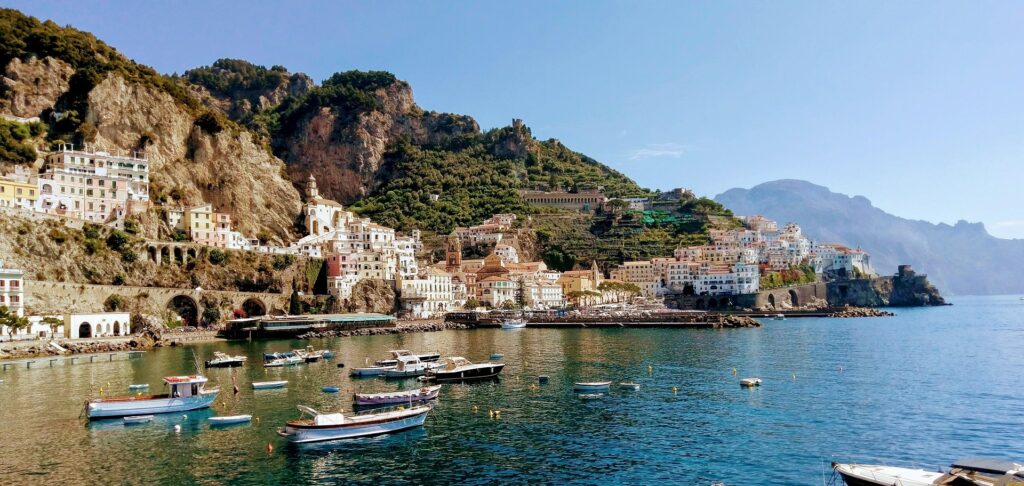
This is the buried story of the Amalfi Coast. The architecture you see — the dense vertical houses stacked on the cliffs, the impossibly compressed town squares, the staircases that climb to the sky — is the working layout of a medieval port city that had almost no flat land to build on. Amalfi sits at the mouth of a steep V-shaped gorge cut by the Canneto torrent into the Lattari Mountains. There is, in literal geographic terms, no room. The town climbs because climbing was the only direction left. The houses are pastel because lime-washing on porous tuff stone was both decorative and structural — the colour was a by-product of the technique. The famous lemons came across the Mediterranean from the Middle East with the early Crusaders in the eleventh and twelfth centuries and were planted on terraced cliff faces because there was no other arable land. The road that now carries tourist coaches along the coast — the Strada Statale 163, the Amalfitana, one of the most filmed roads in Europe — was carved between 1832 and 1853 by Bourbon-era engineers, after a thousand years in which the only way to travel between Positano, Praiano, Amalfi, Atrani, and Ravello was by boat. Nothing on this coast was made for the camera. Everything was made to function on a coastline that should not have had a town on it.
The town did not decline gradually. It declined catastrophically. On the 25th of November 1343, an earthquake off the coast of Naples generated a tsunami that struck the Amalfi Coast in the early evening. The wave destroyed roughly half of the old city of Amalfi, including most of the medieval harbour, the lower arsenal, and a significant portion of the merchant fleet that had been moored there. The Italian poet Petrarch happened to be in Naples that month on a diplomatic mission for the Pope, and described the wave in a letter to a friend — one of the earliest detailed European eyewitness accounts of a tsunami. The political decline of the Republic had already begun by then. The Normans had taken Amalfi in 1131, ending its formal independence. Pisa had sacked it in 1135 and again in 1137. Genoese trade had eaten into its Mediterranean networks for two centuries. But it was the wave of 1343 that finished the city physically. The harbour was gone. The merchant warehouses were gone. The lower city was gone. What remained of Amalfi was the half of the medieval town that sat above the wave’s highest reach — the houses on the cliff, the cathedral on its high platform, the staircases climbing up the gorge. That half is what you see today.
A catholic merchant state
The cathedral of Amalfi — the Duomo di Sant’Andrea — is the single most visible piece of the old republic still in operation. Built between the ninth and thirteenth centuries on the highest point of the medieval town, with a Norman-Sicilian striped facade in green and white marble, sixty-two steps climbing up to its bronze doors, and a baroque interior added in the seventeenth century. The doors themselves were cast in Constantinople in 1066 and shipped here by an Amalfitan merchant named Pantaleone, who had a parallel commercial network in the Byzantine capital. Inside the cathedral, in a crypt below the altar, lie the relics that, according to medieval tradition, were brought from Constantinople in 1208 by an Amalfitan cardinal during the Fourth Crusade: the bones of Saint Andrew the Apostle, brother of Saint Peter. The bones are still there. Pilgrims still come to visit them. The cardinal who delivered them, Pietro Capuano, is buried in the same crypt. The Republic of Amalfi was a Catholic merchant state with its own apostle, its own foreign trade network with the Byzantines, and its own personal cardinal in Rome. None of this looks like a postcard town. All of it is still inside the postcard town.
There are thirteen distinct towns along the Amalfi Coast — Vietri sul Mare at the eastern end, Cetara, Maiori, Minori, Atrani, Amalfi, Conca dei Marini, Furore, Praiano, Positano, and a few smaller villages, ending at Sant’Agata sui Due Golfi above Sorrento at the western end. Each one occupies a different small inlet or cleft in the same chain of cliffs. None of them was originally connected to the others by road. Each was its own micro-economy: Vietri was the ceramic town, Cetara was the anchovy and tuna town, Maiori had the only sand beach for kilometres, Atrani was Amalfi’s smaller twin where the doges of the Republic were elected in the church of San Salvatore de’ Birecto, Positano was a fishing village so small that for most of the nineteenth century half its young men had emigrated to America. Ravello, the inland town clinging to the cliffside above Amalfi, was for centuries the wealthier of the two — the Amalfitan merchant families who made fortunes in the Levantine trade preferred to build their palazzi up there, away from the sea, on a high ledge where the temperature was cooler and the air was clean. Richard Wagner stayed at the Villa Rufolo in Ravello in 1880 and saw in its terraced garden the inspiration for the magic garden of Klingsor in Parsifal. He told the proprietor: “the magical garden of Klingsor is found.” The garden is still there. So is the inscription Wagner left.
The lemons are not folklore. The limone sfusato amalfitano is a specific protected variety — long, tapered, thin-skinned, much sweeter than the Sicilian lemon, grown only on the terraced cliffs of this coast under a Protected Geographical Indication of the European Union. The terraces themselves are a UNESCO-recognised cultural landscape, hand-built over the past thousand years and still maintained by farmers who climb stone staircases to harvest in October, December, March, and May. The fruit is heavier than it looks. The trees are pruned in shapes the family has used for four generations. The limoncello sold in every shop along the coast is the same recipe — alcohol, lemon zest, sugar, water — that an Amalfitan grandmother would have made a hundred years ago for her grandchildren, before any of it was famous, before any of it was on a shelf, before the word limoncello meant anything outside the family kitchen.
This is what the postcard is hiding. The pastel walls are the walls of a working medieval port. The cliff terraces are the agricultural workaround of a town with no fields. The famous lemons are a Crusader import made viable by impossible cultivation. The coastal road is a Bourbon engineering project. The cathedral holds the bones of an apostle and the doors of Byzantium. The hospital order from this town went on to define the Crusader Mediterranean for five hundred years. And the half of Amalfi the wave took in 1343 is still on the seabed offshore, where occasional marine archaeologists have surveyed the foundations of the medieval harbour and the lower neighbourhoods that fell into the sea.
Beauty is rarely what it looks like from a boat. The most beautiful coastline in the world is the wreckage of one of the four maritime empires that ran this sea, weakened by Norman occupation, sacked by Pisans, eaten by Genoese trade, and finished by a wave in November 1343. What remained had to be the half of itself that survived. What survived is what every postcard now shows you, without saying any of this.
Some coasts were made to be looked at. This one was made to function, and what is left is what survived.
Nine regions. One hundred and twenty destinations. Three hundred and thirty-eight weeks remaining.
The journey turns north. The next stop is a city built on water, sinking quietly, refusing to leave.

Beyondia
Trusted Travel CompanionReal digital nomad. I travel. I learn. I grow.
What about you? Where are you going?