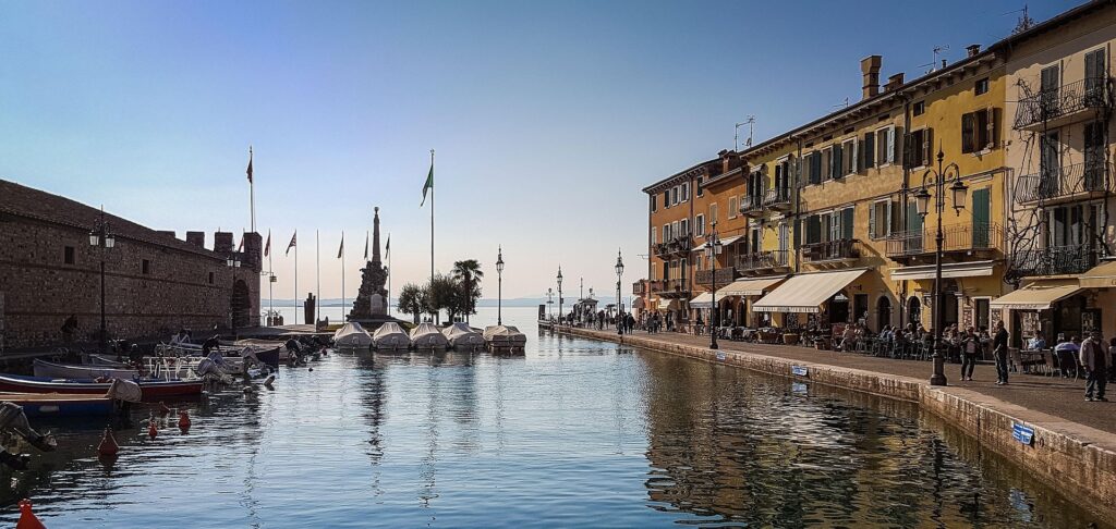
🌐 Around the World with Beyondia 🧵 Mediterranean Region 🪡 Episode 29: Lago di Garda
At the foot of mountains where snow still falls in winter, the same lake grows lemons. Geography this stubborn deserves an explanation.
Lago di Garda — A tongue of the Adige Glacier
Lago di Garda was carved out of solid rock by a glacier between fifteen and eighteen thousand years ago. A tongue of the Adige Glacier — a vast river of ice that filled the Adige Valley during the last Ice Age — broke south through a softer band of limestone and ground out a bowl 52 kilometres long, 17 kilometres wide at its broadest, and 346 metres deep at its deepest point. When the climate warmed and the ice retreated, the bowl filled with meltwater. The lake holds, today, about fifty cubic kilometres of fresh water — enough to supply the city of Milan for several centuries, if anyone needed to. The lake is older than every civilisation that has ever existed in Europe. It is older than the Sumerians, older than the Egyptian pyramids, older than the wheel as a technological invention. The Romans found it already in place. The Etruscans found it already in place. The Neolithic stilt-house communities who built villages along its shores nine thousand years ago — and whose preserved lake-bed dwellings were inscribed on the UNESCO World Heritage list in 2011 — found it already in place. Italy has had a lake longer than Italy has had a name.
The volume of water this lake holds — fifty cubic kilometres of liquid mass, exposed to summer sun and protected from winter freeze by Alpine surrounding terrain — creates a microclimate so distinct that botanists treat the lake’s shores as a separate biogeographic zone from the rest of northern Italy. Olive trees grow on the northern shore. Lemon trees were cultivated commercially along the western shore from the thirteenth century onwards — the town of Limone sul Garda is literally named for them, and the terraced lemon gardens that gave the town its industry are partly preserved as a working museum. Palms, oleanders, capers, bougainvillea, magnolias, and bay trees grow on slopes whose backdrop is the southern face of the Dolomites. The vegetation on the northern shore of Lake Garda is roughly the vegetation of Sicily, growing at the same latitude as Innsbruck, at the base of mountains where snow falls every winter. This is not folk impression. The Köppen climate classification places the upper Garda zone within a Mediterranean subtype despite its alpine surroundings. The lake’s thermal mass is the cause. The water absorbs summer heat and releases it slowly through autumn and winter, keeping the immediate shore line several degrees warmer than the surrounding land. A small slice of southern Italy, in other words, was tucked into the foothills of the Alps by a glacier roughly sixteen thousand years ago, and has been growing fruit there ever since.
The lake’s southern shore is the older inhabited side, and the deepest archaeological layer is on the peninsula of Sirmione — a thin spit of land protruding northward into the lake from the southern shore, roughly four kilometres long, narrowing in places to less than a hundred metres of width. The Roman family that built the villa at the tip of Sirmione was wealthy, well-connected, and probably literary; the poet Catullus, writing in the first century BC, addressed one of his most famous poems to Sirmio, calling it the jewel of all peninsulas. Renaissance archaeologists, finding extensive Roman ruins at the tip and looking for a name to attach to them, identified the site as Catullus’s villa. They were almost certainly wrong — the surviving structure is too large, too late, and too elaborate to have belonged to a private poet — but the name has stuck. The Grotte di Catullo, despite the name, are not grottoes. They are the remains of a Roman villa complex 167 metres long and 105 metres wide, occupying the entire tip of the peninsula, with thermal baths, courtyards, terraces, frescoed walls, and views in three directions across the lake. It is one of the largest preserved Roman villa sites anywhere in northern Italy. The villa was abandoned in the third or fourth century, gradually buried, partially flooded as the lake’s level rose, and excavated systematically from the early nineteenth century onwards. Visitors today walk among standing walls and partial vaults, on a peninsula where olive trees grow between the stone foundations, with the lake on three sides.
The villa was built where it was built because of the thermal springs. Beneath the limestone of the Sirmione peninsula, a deep geological fault releases sulphur-rich water at 69°C — a hot spring system that produces approximately seventy-five litres per second of mineral water from a depth of roughly eight hundred metres below the lake bed. The Romans channelled this water into their bath complex at the villa. After the villa’s abandonment, the springs continued to flow, undirected, into the lake. The springs were rediscovered as a medical resource in the late nineteenth century, when an entrepreneurial Sirmione resident named Procolo Terzi obtained the rights and built the first modern thermal facility. The Habsburg Empire endorsed the springs as a treatment for rheumatic and respiratory conditions. Spa hotels rose around them in the late nineteenth and early twentieth centuries — many of which are still operating, under different ownership, doing essentially the same thing the Romans did. The same water that filled the thermae of a Republican villa now fills modern thermal pools in hotels with names like Catullo and Continental and Aquaria. The Sirmione spring has been producing therapeutic water continuously, at the same temperature, since long before the Roman villa was built. The villa was a customer. The hotels are also customers. The spring runs the franchise.
The lake’s three-region geography is the result of historical accident the article does not need to explain at length but should name. The eastern shore is in Veneto, the western shore is in Lombardy, the northern tip is in Trentino-Alto Adige. The northernmost third of the lake — the Alpine end, dominated by the town of Riva del Garda — was Austrian until 1918, transferred to Italy at the end of the First World War in the same Treaty of Saint-Germain that gave Italy South Tyrol. Riva still has a faintly Habsburg flavour to its architecture: stuccoed townhouses in apricot and cream, a pedestrian centre laid out on Austrian principles, café culture stronger than its Italian neighbours. The southern two thirds of the lake have been Italian for as long as Italy has existed as a country, and were Venetian for the four centuries before that. Garda is, in microcosm, the geographical condensation of northern Italy’s complicated identity — Roman foundation, Lombard medieval governance, Venetian republican administration, Habsburg empire, French intermezzo under Napoleon, Italian state since 1861 for the south and 1919 for the north, three regional administrations now coordinating one lake’s affairs. The boats running ferry services between the lake’s towns cross three regional jurisdictions in a single forty-minute crossing. Most passengers do not notice.
Every era of European cultural history has noticed Garda. Goethe arrived on the lake on the 13th of September 1786, on his Italian Journey, and wrote in his diary that this was the first truly southern landscape he had encountered on his trip down from Weimar. He travelled the western shore by boat, sketching the cypresses and the cliffs of Malcesine, and was briefly arrested by Venetian officials in Malcesine who suspected he was an Austrian spy because he was sketching their fortress. D.H. Lawrence lived on the lake’s western shore at Gargnano in 1912–1913 with his future wife Frieda, and wrote Twilight in Italy there — his first serious travel book, and one of the foundational texts of modernist travel literature. Mussolini, in the final eighteen months of his life, was installed by the Germans as the puppet head of state of the Repubblica Sociale Italiana — the Republic of Salò — and his government was headquartered in lakeside villas along Garda’s western shore between 1943 and his execution by partisans in April 1945. The lake’s most beautiful villas, in those last twenty months of European Fascism, housed war criminals. After the war, the villas became hotels. The dark coda is folded into the contemporary tourism. Most visitors do not know they are sleeping in a building where a Fascist undersecretary signed deportation orders in 1944. Garda absorbs its history in the same way the lake absorbs its summer heat — slowly, without comment, and gives it back later as ambient warmth.
The northern third of the lake — the narrow Alpine end where the mountain walls close in and rise sharply on both sides — is now one of the world’s three or four most consequential windsurfing destinations. The reason is geological. The lake’s narrow northern bay produces two reliably strong, predictable winds, in opposite directions, at known times of day, twelve months of the year. Each morning, cold dense air drains down from the Brenta and Adamello peaks into the lake, producing a steady northerly wind called the pelèr — Venetian dialect for peeler, perhaps from the cold edge it carries. The pelèr runs from before dawn until about ten in the morning. The lake’s surface then begins to warm, the air above it rises, and by early afternoon a southerly thermal wind called the ora fills the upper lake, blowing from south to north until just before sunset. Two winds. Twelve hours apart. Twelve months a year. Sailors plan their days around them with the precision of a railway timetable. The Italian Olympic sailing team trained at Riva del Garda for decades. The world windsurfing championships have been held here repeatedly. The ora is so regular that hotels publish its expected daily start time on noticeboards in the lobby, the way some hotels publish high-tide times. Wind, on Garda, is infrastructure. The mountain walls are the engine. The lake is the propeller. The system has been running since the glacier left.
Some lakes are scenery. This one is a small Mediterranean climate, a large Roman villa, three regional governments, a German poet’s first taste of the south, the last hideout of European Fascism, a hot spring with a Roman customer history, and a wind reliable enough to set your watch by — all in one body of water, sixteen thousand years old, held in a bowl of limestone the Alps did not realise they had cut.
Nine regions. One hundred and twenty destinations. Three hundred and thirty-two weeks remaining.
The journey continues west. The next stop is a port whose name became the name of a flower festival, and whose flower festival became the name of a country’s song.

Beyondia
Trusted Travel CompanionReal digital nomad. I travel. I learn. I grow.
What about you? Where are you going?