🌐 Around the World with Beyondia 🧵 Mediterranean Region 🪡 Episode 46: Lanzarote
Lanzarote is one thousand kilometres south of Madrid, one hundred and twenty-five kilometres off the coast of southern Morocco, and geologically in Africa in every sense the geology cares about.
Lanzarote-born artist who came home from New York in 1968
The island rose from the Atlantic seabed roughly fifteen million years ago in a series of volcanic eruptions produced by the same tectonic hotspot that produced the rest of the Canary archipelago — Tenerife, Gran Canaria, Fuerteventura, La Palma, La Gomera, El Hierro. Lanzarote is the northernmost and, at approximately fifteen million years old, the oldest of the seven Canary Islands. It is 845 square kilometres in area, roughly 60 kilometres long from north to south and 25 kilometres wide at its broadest point. It has a permanent population of approximately 155,000 people, most of them concentrated in the capital Arrecife on the eastern coast, and it receives approximately three million tourists per year — a ratio of visitors to residents that would, in almost any other European tourist island, have produced by now the same kind of unregulated resort landscape that has damaged Tenerife, Gran Canaria, Mallorca, Ibiza, and the entire Spanish Mediterranean coast from Barcelona to Málaga. Lanzarote did not produce that landscape. What Lanzarote produced instead is one of the most sustained acts of aesthetic preservation in modern European tourism, and the reason it exists is a single Lanzarote-born artist who came home from New York in 1968 and did not stop working until his death in a car accident twenty-four years later. His name was César Manrique. He is the reason this island looks the way it does, and he is the article’s central subject.
Manrique was born in Arrecife on the 24th of April 1919, the son of a small landowner. He studied technical architecture in Tenerife in the 1940s, moved to Madrid in 1945, and became part of the post-war Spanish artistic community centred around the Círculo de Bellas Artes and the emerging abstract-expressionist movement. He exhibited across Spain, then across Europe. In 1964 he was given a Nelson Rockefeller Fellowship and moved to New York, where he lived until 1966, exhibited at the Catherine Viviano Gallery, met the American abstract-expressionist establishment, and became friends with, among others, Andy Warhol. He was, by the mid-1960s, one of the more internationally recognised Spanish contemporary artists of his generation. Then, in 1966, he decided to return home. The story he later told was that he had been walking on Fifth Avenue in Manhattan and had realised, suddenly and with unusual clarity, that he needed to spend the rest of his life on Lanzarote. He arrived permanently in 1968. Manrique was forty-nine years old. He had, in the event, twenty-four years left to live. He spent them all on the island.
What he did with those twenty-four years is the article’s central story. The context is important. Between 1960 and 1970, the Franco regime — which had opened Spain to European tourism as an economic development strategy from the mid-1950s onward — presided over the fastest and most environmentally destructive coastal-development boom in modern European history. Along the Costa Brava, the Costa Blanca, the Costa del Sol, and the tourism strips of Mallorca and Ibiza, thousands of high-rise hotels were built in less than fifteen years, largely without planning oversight, in an architectural language that made a specific and permanent choice to prioritise the maximum extraction of tourist revenue per square metre of coastline over any consideration of the landscape being built on. Tenerife and Gran Canaria — the two most-visited Canary Islands — began to receive the same treatment in the mid-1960s: Playa de las Américas on Tenerife, Playa del Inglés on Gran Canaria, high-rise strips of hotels along the southern coasts of both islands, unregulated and, in the retrospective judgement of most Canarian architects and planners, permanently damaging. Manrique arrived on Lanzarote in 1968 knowing exactly what he was trying to prevent. The tools he used were three: personal advocacy with the local government (the Cabildo Insular de Lanzarote, the island council, which had substantial local planning autonomy under the Franco regime and continued to have it under the democratic transition after 1975), personal design commissions for the small number of public tourism sites that were being developed by the Cabildo itself, and personal example — Manrique’s own house, his own studio, and the buildings he designed for public visitors became demonstration objects of what the island’s built environment could look like.
Lanzarote’s distinct visual identity
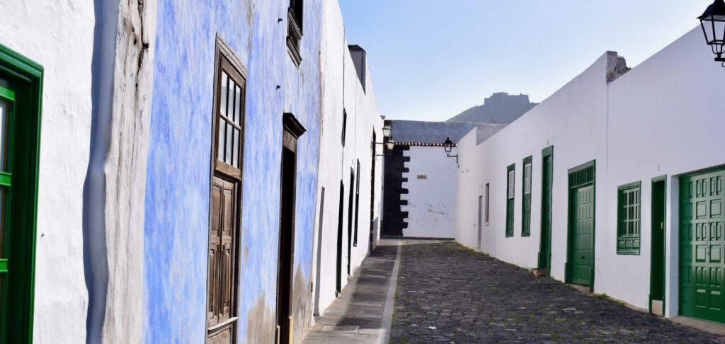
The regulatory tools came first. Manrique persuaded the Cabildo Insular to pass a series of building regulations in the late 1960s and early 1970s that were, in their time, essentially unprecedented in Spanish or European tourism-management law. The principal provisions: no residential or commercial building above two storeys anywhere on the island, except in three specifically designated tourism zones (Puerto del Carmen, Playa Blanca, and Costa Teguise) where limited exceptions were allowed. All traditional buildings — homes, small businesses, agricultural buildings — to be whitewashed exteriors with green window frames and doors in the interior of the island, and blue window frames and doors on the coast. No commercial billboards anywhere on the island, on any road, in any settlement. No overhead electrical wires or telephone cables in most of the island’s interior (all such infrastructure to be underground). No neon signage. No plastic advertising. Detailed regulations on new construction to integrate with existing volcanic terrain rather than levelling it. The regulations were passed. They were enforced. They are still enforced. A visitor driving from Arrecife airport to any part of the island in 2026 will not see a single billboard, will see no building over two storeys tall outside the three designated tourism zones, will see white houses with green or blue trim in every village, and will see almost no overhead wires. The island looks, in significant part, exactly as Manrique wanted it to look in 1968. The regulations survived Franco’s death, the democratic transition, the six Spanish democratic constitutions and thirteen governments that have followed, three property-development booms, and one major recession. The island council has not repealed them. They are considered, across the Canaries, as the foundational reason for Lanzarote’s distinct visual identity and its continued attractiveness to the higher-spending, lower-volume international tourism that the more damaged islands are now trying to attract back.
The demonstration objects came second. Beginning in 1966 and continuing until his death, Manrique personally designed seven major public sites on Lanzarote, each carefully integrated into the volcanic landscape rather than imposed on it. The Jameos del Agua — opened in 1966, the first of Manrique’s public commissions — is a natural volcanic-tube complex on the north coast, converted into a subterranean auditorium, restaurant, and small lake. The auditorium seats 550 people inside a natural lava-cave chamber; performances are held there year-round. The small lake contains a species of blind albino crab (Munidopsis polymorpha) found nowhere else in the world. The Mirador del Río (1973) is a viewpoint on the northern cliffs of the island, looking across the strait to the small island of La Graciosa, designed as a building carved into the cliff face so that from below it is nearly invisible. The Jardín de Cactus (1990) is a botanical garden of 4,500 cactus specimens across 450 species, designed in a decommissioned volcanic-ash quarry with the entire garden layout following the quarry’s contours. The Cueva de los Verdes (opened as a public site 1964) is a further section of the same volcanic tube as the Jameos del Agua, arranged as a walking route with lighting and small concert spaces. The Monumento al Campesino (1968) is a monument and cultural centre on the central plateau of the island honouring the traditional Lanzarote farmer. The Restaurante El Diablo (1970) is the visitor restaurant at the Timanfaya national park, where meat is grilled over a natural geothermal grate connected to the still-hot ground beneath. The Fundación César Manrique (Manrique’s own home and studio, opened as a public foundation in 1992, four months after his death) is a house built directly into five contiguous volcanic bubbles — natural spherical cavities produced by trapped gas in cooling lava — connected by tunnels, with the living spaces integrated with the black volcanic-rock walls of the bubbles. These seven sites are, together, one of the most significant single-architect bodies of public architecture in twentieth-century Spain. They receive approximately two million visitors per year between them. They are also the working demonstration of the aesthetic principle Manrique was asking the rest of the island to follow: build with the volcanic landscape, not on top of it.
Manrique died on the 25th of September 1992, at the age of 73, in a car accident at a roundabout near his home. He had been driving to a meeting with the Cabildo Insular about further preservation measures. The circumstances were entirely ordinary: another car failed to give way at the roundabout, and Manrique’s car was struck at low speed. He died at the scene of head injuries. The news reached Madrid within an hour and caused the closure of the Canary Islands’ regional parliament for the day. The following year, in 1993, UNESCO designated the entire island of Lanzarote as a Biosphere Reserve — the first Canary Island to receive the designation, and one of the earliest such designations in the world for a substantially populated island. The UNESCO citation explicitly acknowledged Manrique’s preservation work as one of the reasons the island qualified. The Fundación César Manrique opened as a public museum on the 27th of March 1992, six months before his death, and has continued as one of the most-visited cultural sites on the island. His personal collection of works by Picasso, Miró, Klee, Chagall, Warhol, and others hangs on the walls of the house he had built into the volcanic bubbles. The house is preserved as he left it. The paintings are not on tour. The volcanic bubbles have not been modified. The island continues to enforce the building code.
One third of Lanzarote’s surface is covered by the lava
The landscape Manrique preserved is one of the most extraordinary on Earth. Approximately one third of Lanzarote’s surface — around 250 square kilometres — is covered by the lava fields produced by the Timanfaya eruption of 1730–1736, which is one of the longest continuous volcanic eruptions ever recorded in human history. The eruption began on the 1st of September 1730 in the central-southern part of the island and continued, with varying intensity but without complete cessation, for six years. Eleven villages were destroyed in the first two years. Approximately half the population of the island (which at the time was about six thousand) was displaced. The eruption is documented in exceptional detail in the journal of Andrés Lorenzo Curbelo, the parish priest of the village of Yaiza, who kept a day-by-day account of the eruption from September 1730 until his own displacement, and whose journal — still extant, preserved in the Canary Islands archives — is one of the most valuable early-modern volcanological documents in existence. Curbelo’s journal describes the flowing lava, the ash rains, the earthquakes, the sulphurous gases, the destruction of crops, the flight of the population, and the profound psychological effect on the surviving villagers of watching one third of their island disappear under molten rock over the course of six years. The eruption ended in April 1736. The landscape it left is the Timanfaya national park (Parque Nacional de Timanfaya, designated 1974) — a 51 square kilometre area of raw volcanic terrain that has not vegetated in the three centuries since the eruption because the underlying rock remains geothermally active. The temperature four metres below the ground surface in the central Timanfaya area still exceeds 400°C. National park staff demonstrate this daily by pouring buckets of water into ground-level pipes, producing instant six-metre geysers of steam. The Restaurante El Diablo that Manrique designed at the park’s visitor centre grills its chicken and lamb over a natural geothermal grate — a metal grille laid over an opening in the ground, with heat rising from the geothermally active rock four metres below. The lava is still hot. The eruption ended within human institutional memory — Curbelo’s grandson could have met him. Lanzarote is, geologically, one of the youngest human-inhabited landscapes in Europe.
The agricultural response to the 1730–1736 eruption is the island’s other extraordinary landscape. The eruption covered approximately a quarter of the island’s most fertile agricultural land with a layer of volcanic ash (the picón, or rofe) between two and five metres thick. The ash was, in the initial decades after the eruption, considered useless — the underlying soil was buried, and the ash could not itself support conventional agriculture. Then, in the late eighteenth century, the surviving farmers of Lanzarote discovered by experiment that vine grapes would grow in the picón if planted in specific ways: the vines were placed in individual hollows dug 2–3 metres deep into the ash, exposing the underlying soil at the bottom, and each hollow was shielded from the constant Atlantic trade winds by a semicircular dry-stone wall built on the wind-facing side. The vines rooted through the ash into the underlying soil. The picón acted as an overnight moisture sink, condensing dew from the humid ocean air and slowly releasing it back to the vine roots. The trade winds, which would otherwise have desiccated exposed vines, were deflected over the top of each hollow by the stone walls. The system worked. It has been in continuous use since the late eighteenth century, developed and refined over generations by a specialised Lanzarote agricultural tradition. Approximately ten thousand of these vine hollows are still cultivated today, principally in the La Geria wine region in the central-southern part of the island, in a landscape that looks like nothing else on Earth: geometric fields of semicircular black stone walls stretching across grey-black volcanic ash, with green vines emerging from each hollow, arranged in patterns visible from the air as thousands of individual dark half-moons across the ash fields. The vines produce Malvasía Volcánica grapes (a Canary Islands variety of the Malvasia grape) that make one of the most distinctive white wines in the Atlantic. The wine has protected geographical indication (Denominación de Origen Lanzarote, 1993) and is exported in small quantities to specialist buyers across Europe and North America. The landscape is, together with the Timanfaya lava fields, one of the two visual signatures of Lanzarote, and it is the working example — as Manrique’s public sites are — of the principle that the island’s people have applied since the eruption ended: work with the volcanic land, not against it.
The other Canary landscapes and cultural artefacts complete the layered Lanzarote. The northern coast — cliffs of up to 500 metres facing the small island of La Graciosa across the El Río strait — is one of the most dramatic seascapes in the Atlantic. The eastern coast at Arrecife, the capital, has substantial commercial fishing and a small but functioning harbour. The southern beaches, particularly around Playa Blanca and Papagayo, are white-sand and turquoise-water beaches formed of ground shell rather than volcanic material. The traditional cuisine is Canary — papas arrugadas (small potatoes boiled in heavily salted water until the skins wrinkle, served with mojo picón red pepper sauce and mojo verde green coriander sauce), ropa vieja (a shredded beef stew), puchero canario (a rich stew of vegetables, meats, and legumes), and grilled fresh Atlantic fish (vieja, the Canary parrotfish; sama, the local dentex; cherne, the wreckfish). The Canary Islands have their own musical tradition centred on the timple, a small five-string plucked instrument with a distinctive high, chiming sound, used across the archipelago in folk music. The timple is closely related to but genuinely distinct from the mainland Spanish guitar family, and its unique sound is one of the identifying features of Canary music. The language spoken is Spanish, in the specific Canary dialect that has significant Portuguese and West African substrate (reflecting the archipelago’s historical connections to Madeira, the Cape Verde islands, and West African trade routes), and that shares many features with Latin American Spanish because Canary emigration to the Americas — particularly to Cuba, Venezuela, and Puerto Rico — was one of the largest single migration streams within the Spanish empire between the seventeenth and nineteenth centuries. The Canary Islands are, in cultural terms, the bridge between mainland Spain and Spanish America. A Cuban visitor to Lanzarote will hear a Spanish that sounds unusually familiar. A Venezuelan visitor will find the same. This is not accidental. This is inheritance.
The contemporary island functions on a policy model that most other tourist islands are, in 2026, actively studying. Approximately three million visitors per year, absorbed into a landscape that shows very little visible evidence of them; three designated tourism zones concentrating the resort infrastructure; a permanent ban on billboards and high-rise construction across the rest of the island; a UNESCO Biosphere Reserve designation that provides continued regulatory authority; a strong culture of local architectural conservation; a specialised agricultural economy producing internationally exported specialty wines from a landscape that would be considered agriculturally impossible on any other geological substrate; a small but functioning fishing economy; and one of the most distinctive public-visitor programmes anywhere in Spain, based on the seven Manrique sites plus the Timanfaya national park and the La Geria wine landscape. Lanzarote is not perfect. Housing prices in the coastal villages have risen substantially over the past decade. The tourism zones do show the standard resort-strip character in concentrated form. The island’s water supply — like all the Canary Islands, Lanzarote has essentially no freshwater sources and depends on desalination for almost all drinking water — is under increasing pressure. But the island is functioning at a level of environmental and aesthetic coherence that almost no other European tourist island has managed to sustain. The Lanzarote model is being cited in policy discussions in the Balearic Islands, in the Costa del Sol regional government, in the Cabo Verde archipelago, in Madeira, and increasingly in the Caribbean island administrations that are looking for alternatives to the resort-strip model that has damaged so much of their coastlines. Fifty-eight years after Manrique came home from New York, his model is being copied by island administrations that have never heard his name.
This is the deeper character of Lanzarote. The island is a UNESCO Biosphere Reserve whose designation was a direct recognition of the preservation work of a single artist who spent twenty-four years persuading a small island council to hold the line. The volcanic landscape produced by the six-year Timanfaya eruption of 1730–1736 is still geothermally active and grills chicken by ground heat at a national park restaurant designed by the same artist. The agricultural landscape of the La Geria wine region, developed by generations of surviving farmers after the eruption, produces one of the most distinctive white wines in the Atlantic on ten thousand hand-dug vine hollows in volcanic ash. The traditional architecture is white with green or blue trim, the buildings are two storeys maximum outside the three tourism zones, the roads have no billboards, and the seven public visitor sites the artist designed remain the most-visited cultural attractions on the island. The Canary Spanish is closer to Cuban and Venezuelan Spanish than to Madrid Spanish. The timple still sounds through the folk music of the island. And the artist, César Manrique, who died in a car accident in 1992 at the age of seventy-three, is buried in a small cemetery on Lanzarote in a grave he chose himself, with a view of the volcanic landscape he had spent twenty-four years protecting. Most cities and most islands are the product of thousands of individual decisions accumulated over centuries. This one is largely the product of one man’s decisions, held over decades, accepted by a small island council, and enforced continuously since. The island is his legacy. It is also, still, itself.
Some places were shaped by many hands. This one was shaped by one man, who came home from New York in 1968, worked for twenty-four years, and left an island that still refuses to be like the others.
Nine regions. One hundred and twenty destinations. Three hundred and sixteen weeks remaining.
The journey continues south. The next stop is a smaller sister island that has doubled the population of the human race to permanent residents in a single generation, and lives on a diet of tomatoes and wind.

Beyondia
Trusted Travel CompanionReal digital nomad. I travel. I learn. I grow.
What about you? Where are you going?