Route: Rovinj → Plitvice Lakes → Dubrovnik Total distance: 700 km Total driving time: 9–10 hours (without stops) Recommended duration: 5–7 days Best months: May–June, September–October Roads: Istrian Y (A8/A9), A6, A1 Autocesta, D8 coastal road, Pelješac Bridge
The Shape of This Drive, Rovinj to Dubrovnik
This route crosses Croatia diagonally — from the Istrian peninsula in the northwest to the Dalmatian tip in the southeast. It covers nearly the entire country, which is smaller than you think and more varied than you expect. You start in a town that feels half-Italian, drive inland through mountains and forests to a national park built around sixteen lakes connected by waterfalls, then turn south and follow the longest motorway in the country all the way down the coast until the road ends at a walled city that looks like it was built to be the last thing you see before the sea takes over.
Three landscapes. Three completely different versions of the same country. Istria is quiet, Mediterranean, and truffle-scented. The Plitvice interior is forested, cool, and older than anything you’ve seen so far. The Dalmatian coast is limestone, light, and built for the Adriatic the way Venice was built for the lagoon — except here the stone is white and the water is clear enough to see the bottom from the road above.
You are driving the length of a country that was, until 1991, part of Yugoslavia. The motorway you’ll use for most of the journey didn’t exist twenty years ago. The bridge that connects Dubrovnik to the rest of Croatia opened in 2022. This is not an ancient road. It is a new country’s infrastructure, built fast and built well, connecting a coastline that history spent centuries dividing.
Stage One — Rovinj to Plitvice Lakes
Distance: 250 km Driving time: 3–3.5 hours Toll cost: approximately €10–15 Road: A8/A9 (Istrian Y) to A6 to A1, exit at Gornja Ploča, then D1
Leave Rovinj in the morning. The town sits on a small peninsula — one road in, one road out — and by the time you’ve cleared the harbour and the church of St. Euphemia has disappeared from your mirror, you’re on the Istrian Y motorway heading north toward Rijeka.
The Istrian Y is a tolled motorway operated by Bina Istra, separate from the national highway system. It connects Pula in the south to the A6 motorway heading east toward Zagreb and the interior. The road is smooth, modern, and mostly empty outside of July and August. You’ll pass through the Učka Tunnel — a 5-kilometre bore through the mountain range that separates Istria from the rest of Croatia. There’s a separate toll for the tunnel. After it, the landscape changes completely. Istria’s gentle hills give way to the steeper, greener Gorski Kotar region as you merge onto the A6 toward Bosiljevo.
At Bosiljevo, you change to the A1 heading south. This is Croatia’s main motorway — the spine of the country, running from Zagreb all the way to Ploče near the coast. You won’t stay on it long for this leg. After about 85 km, take the exit at Gornja Ploča and follow the D1 road south toward Plitvice.
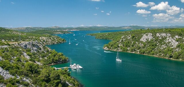
The D1 is a two-lane road through forest. This is where the drive changes character. The motorway dissolves into something older and slower — farmhouses, honey stalls at the roadside, hand-painted signs for cheese and rakija. If you pass through the small town of Slunj, stop. Just before Plitvice, Slunj sits above the Korana river at a place called Rastoke, where the river splits into waterfalls that run between and underneath old mill houses. It’s a fifteen-minute detour and it recalibrates your expectations for what water does in this part of the country.
Plitvice Lakes — The Interior
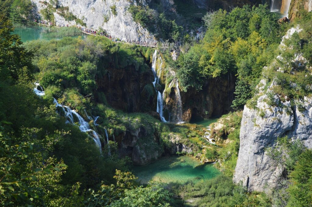
Plitvice Lakes National Park is a UNESCO World Heritage Site and the most visited place in Croatia. Sixteen lakes connected by waterfalls, arranged over two levels — the Upper Lakes and the Lower Lakes — fed by rivers that have been depositing travertine for thousands of years, building new barriers and redirecting their own flow as they go. The water is not dyed. It is not filtered. It is that colour because of the minerals and the light and the depth, and it changes through the day in ways that make you stop trusting your memory of what you saw an hour earlier.
Practical information, because this place requires planning. There are two entrances. Entrance 1 is closer to the Lower Lakes and the Great Waterfall — Veliki Slap — which at 78 metres is the tallest waterfall in Croatia. Entrance 2 is closer to the Upper Lakes, which are wider, calmer, and connected by boardwalks over the water. If you have one day, start at Entrance 1 in the morning, walk the Lower Lakes, take the electric boat across Lake Kozjak — the largest — and continue into the Upper Lakes. The park’s internal shuttle bus returns you to your starting entrance.
Buy tickets online before you arrive. During summer, the park caps daily visitor numbers and specific entry time slots sell out days in advance. Off-season — April, May, late September, October — the crowds thin and the colours intensify. The park is open year-round, though winter access is limited and some boardwalks close.
Give Plitvice a full day. Stay overnight nearby rather than trying to drive to Dubrovnik the same day. The park area has guesthouses and small hotels along the D1, most of them family-run, most of them modest, almost all of them better value than anything on the coast. Eat lamb or trout. You are in the mountains now, not the Mediterranean, and the food knows it.
Stage Two — Plitvice Lakes to Dubrovnik
Distance: 450 km Driving time: 5.5–6.5 hours Toll cost: approximately €25–30 Road: D1 south to A1, then A1 to Ploče, then D8 and Pelješac Bridge
This is the long leg. Five and a half hours without stops, closer to seven or eight if you stop where you should. Leave Plitvice early.
From the park, take the D1 south through Korenica to Udbina. The road is scenic in the way that honest mountain roads are scenic — not curated, just high and open and quiet. At Udbina, signs direct you to the A1 motorway. The descent from the mountain plateau onto the motorway is dramatic — tunnels cut through the Dinaric Alps and the road drops toward sea level in long, sweeping curves. You’ll know you’re getting close to the coast when the vegetation changes from dark forest to pale scrub and the air through the vents starts tasting like salt.
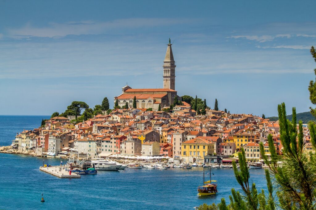
The A1 carries you south past Zadar, past Šibenik, past the Split bypass. Each of these cities deserves its own trip. If you have time, Split is the one to stop in — Diocletian’s Palace sits in the centre of a living city the same way the Roman ruins sit inside Rome, except here the palace walls have become apartment buildings and the basement level is a market. But if Dubrovnik is pulling you forward, stay on the A1.
The motorway ends near Ploče. This is important: there is no motorway to Dubrovnik. The A1 simply stops, and you merge onto the D8 — the old Adriatic coastal road, a two-lane highway that follows the shoreline south. The D8 is beautiful and slow. In summer, it’s crowded. Budget extra time for this section.
Shortly after Ploče, you’ll reach Komarna, where the road splits. To the left, the old route continues to Neum — a 9-kilometre strip of Bosnian coastline that cuts Croatia in two, a geographic anomaly that dates back to 1699 when the Republic of Dubrovnik handed it to the Ottomans as a buffer against Venice. Until 2022, every driver heading to Dubrovnik had to cross two international borders within those 9 kilometres.
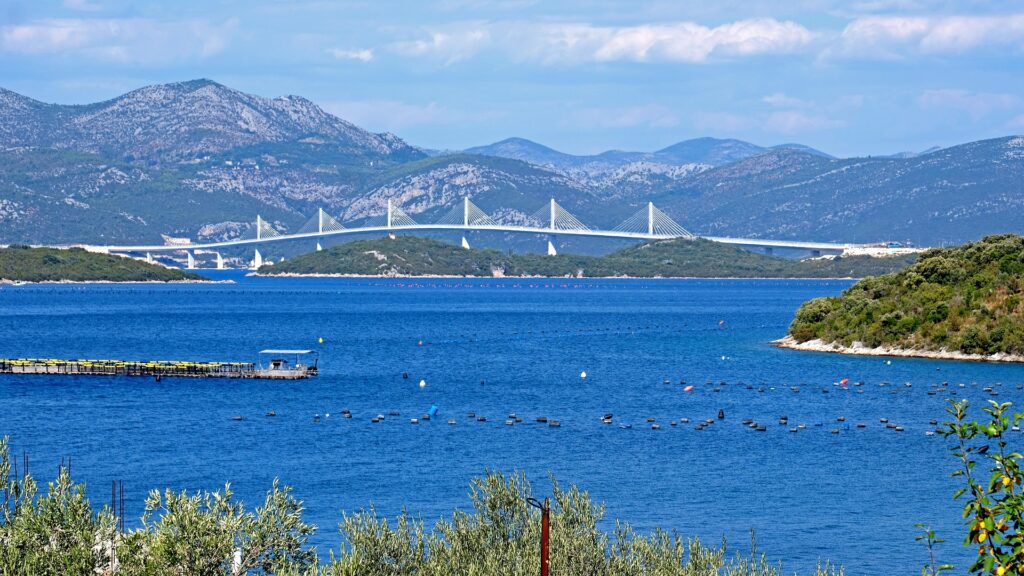
To the right is the Pelješac Bridge.
The bridge is 2.4 kilometres long, cable-stayed, 55 metres above the water, and entirely free to cross. It opened in July 2022 and connects the Croatian mainland to the Pelješac peninsula, bypassing Bosnia entirely. Driving across it is a moment — the Adriatic opens on both sides, the peninsula rises ahead of you, and you understand in a physical way that this bridge exists because a country needed to stitch itself back together.
After the bridge, the road crosses the Pelješac peninsula through two tunnels and descends toward Ston, a small town famous for its salt pans and its oysters and a defensive wall that once stretched five kilometres across the peninsula — sometimes called the European Great Wall, which oversells it, but the scale is still surprising. From Ston, the road follows the coast south through increasingly beautiful and increasingly empty landscape until it rounds a headland and Dubrovnik appears below you, white and walled, on a promontory above the sea.
Arriving in Dubrovnik
Dubrovnik is a small city with a large reputation and a very specific parking problem. The Old Town is entirely pedestrianised. Cars stop well outside the walls.
The main parking areas are at Gruž — near the port and the bus station, northwest of the Old Town — and at Ilijina Glavica, closer to the Pile Gate entrance. Expect to pay approximately €5–8 per hour in high season. If your accommodation is inside or near the Old Town, confirm parking arrangements before you arrive. Many hotels and guesthouses have agreements with nearby garages or offer advice on where to leave the car. Some streets near the Old Town have resident-only access enforced by retractable bollards.
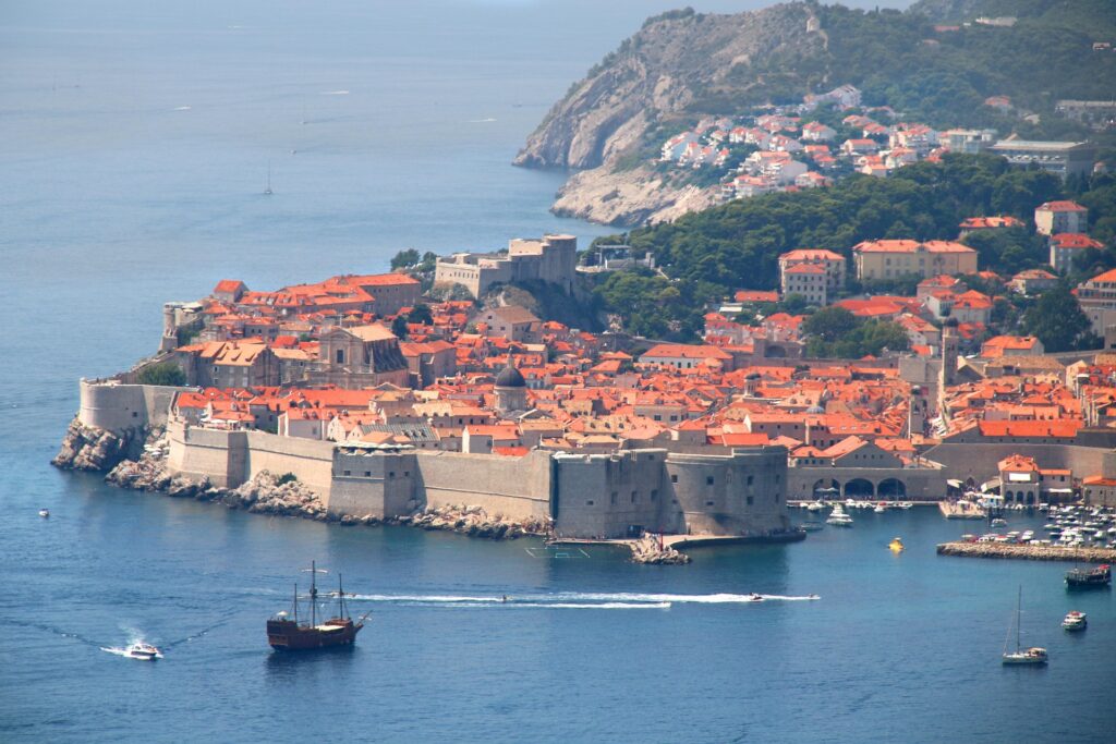
If you arrive from the north via the Pelješac Bridge route, you’ll approach Dubrovnik on the D8 from the west. The road descends through suburbs and passes above Gruž harbour before signs direct you toward the Old Town. The first view of the walls from the road above is the moment every tourist photograph has been trying to capture and none has quite managed.
Practical Notes
Tolls: Croatia uses a distance-based toll system. You take a ticket when entering the motorway and pay when exiting. Cash and cards are both accepted at all booths, including contactless. Budget approximately €40–50 in total tolls for the full Rovinj-to-Dubrovnik route, including the Istrian Y and the A1. The Pelješac Bridge is free.
Fuel: Stations are well-spaced along the A1. Prices are slightly higher on the motorway than in towns. Fill up before entering the D1 toward Plitvice — stations thin out in the interior. Croatia prices fuel in euros since joining the eurozone in January 2023.
Speed: The posted limit on Croatian motorways is 130 km/h. Speed cameras are common, well-signed, and not forgiving. On the D8 coastal road, limits drop to 50–80 km/h depending on the section, and the road’s curves enforce those limits more effectively than any camera.
The A1 in summer: Saturdays are changeover days for weekly holiday rentals along the coast. The A1 between Zagreb and Split becomes extremely congested on Saturday mornings from late June through August. If you’re driving this route in high season, leave Plitvice on a weekday morning. Tuesday or Wednesday gives you the best odds of a clear road.
Plitvice tickets: Book online at the official park website. In peak season, entry is timed and capped. Arrive at your designated slot. The park does not accept walk-ups when sold out, and it does sell out. Off-season is more flexible but still benefits from advance booking.
The Neum alternative: You can still drive through Bosnia via the old Neum corridor if you prefer. The Pelješac Bridge is the faster, simpler option and avoids border crossings entirely. If you do take the Neum route, you’ll need your passport — Croatia is in the Schengen Area, Bosnia is not. The crossing is usually quick outside of summer weekends, but the border checks are real.
Season: May, June, and September are ideal. The coast is warm, the interior is green, Plitvice is at its most photogenic, and the A1 is navigable. July and August bring heat, crowds, and motorway congestion that can add hours to the southern leg. October is quieter and cooler, with shorter days and autumn colour in the Plitvice forests that justifies the trip on its own.
HAK app: Download it before you drive. HAK is the Croatian Auto Club and their free app provides real-time traffic, road closures, fuel prices, and weather. The emergency number for breakdowns in Croatia is 1987. General emergencies are 112.
What This Road Is Really About
Most people visit Croatia in pieces. They fly to Dubrovnik, or they drive down to Istria, or they stop at Plitvice on the way from Zagreb to Split. This route connects all three in one continuous drive, and in doing so it shows you something most visitors miss: Croatia is not a coastline with a country behind it. It is a country with three completely different landscapes that happen to share a flag and a complicated recent history.
Istria whispers Italian and smells like truffles and olive oil. The Plitvice interior is silent, forested, and untouched by the Adriatic influence that shapes everything on the coast. Dalmatia is stone and light and a thousand years of Venetian architecture baking in the sun. You drive through all three in a single route, and by the time you reach Dubrovnik you understand that the country held together not because these places are similar but because they decided to be one thing despite being many things.
The road ends at a walled city on the edge of the Adriatic, looking southeast across open water.
After that, the sea.
🔍 Related GoBeyondia Journeys
- 🇭🇷 Croatia — The Shimmering Adriatic Gateway
- The Colour That Has No Reason — Croatia Trip
- The Steps at The Adriatic
- Tracing Light: A Journey to Croatia’s Edge

Beyondia
Trusted Travel CompanionReal digital nomad. I travel. I learn. I grow.
What about you? Where are you going?