Around the World with Beyondia 🧵 Mediterranean Region 🪡 Journal 16
Lanzarote. Tenerife. Gran Canaria. Three islands that hold Spanish passports but answer to volcanoes, trade winds, and the Sahara.
Lanzarote doesn’t look like earth
I flew south from the mainland expecting more Spain. Two hours later I landed on the surface of another planet.
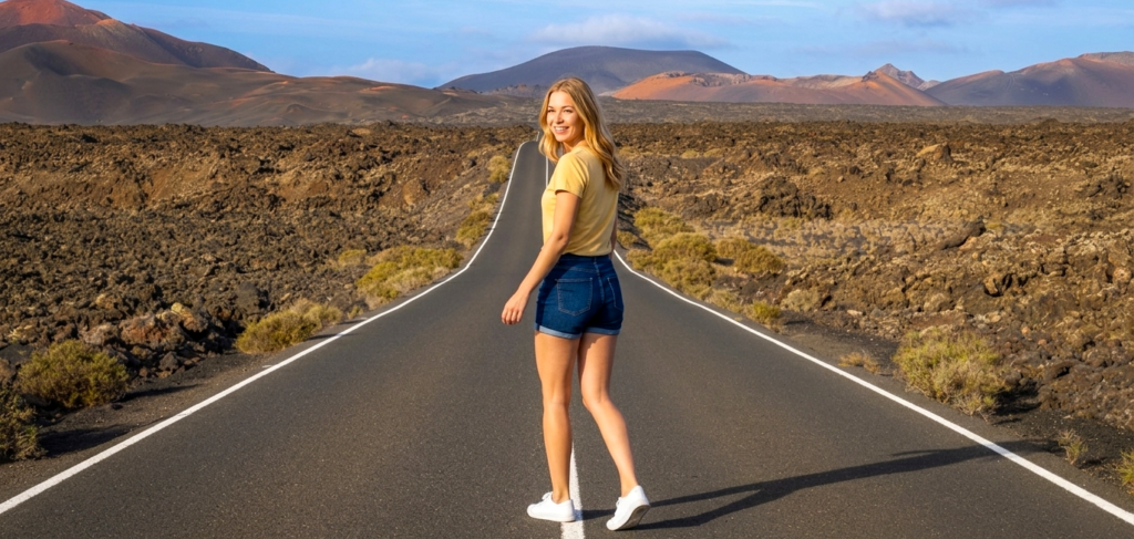
Lanzarote doesn’t look like earth. It looks like earth gave up and started over. The island erupted between 1730 and 1736 — six continuous years of volcanic eruption that buried a third of the surface under lava. Timanfaya National Park is what remains — a landscape of black and red rock, craters, collapsed tubes, and a silence so total that the first sound I noticed was my own breathing. The park rangers demonstrated the heat by pouring water into a pipe drilled a few metres into the ground. It erupted back as steam instantly. The ground is still cooking. Three hundred years later, the volcano hasn’t finished.
I drove through the wine region of La Geria and found something that should be impossible. Vineyards. On lava. The farmers dig semicircular pits into the volcanic ash, plant a single vine at the bottom, and build low stone walls called zocos around each one to protect it from the constant wind. Thousands of these crescent-shaped hollows stretch across the black landscape like a civilisation of small mouths, each one holding a single green vine against all odds. The Malvasía wine that comes from these vines is dry, mineral, volcanic — it tastes like the ground it fought to grow from. Lanzarote doesn’t farm. It negotiates with geology.
César Manrique is the reason the island looks the way it does, and the reason it doesn’t look the way it could have. The artist and architect was born here, studied in Madrid, lived in New York, came back, and spent the rest of his life fighting to protect Lanzarote from the tourism development that had already consumed much of the Canaries. No building on the island is taller than three storeys. No billboard breaks the horizon. The Jameos del Agua — a volcanic cave system that Manrique transformed into an underground concert hall, restaurant, and pool built inside a collapsed lava tube — is the proof that architecture and landscape can be the same act. I walked through it and the boundary between what the volcano made and what Manrique designed was invisible. That was the point. He didn’t build on Lanzarote. He built with it.
His foundation — his former home, now a museum — is built into five volcanic bubbles, lava chambers connected by tunnels, a swimming pool surrounded by black rock, white walls, and the kind of light that only exists where the Sahara trades air with the Atlantic. Manrique died in a car accident in 1992 at a junction he’d spent years campaigning to make safer. The island he saved from development still follows his rules thirty years later. Not many artists change the law. Manrique changed the landscape by refusing to let the law ignore it.
Tenerife was vertical.
I landed on the southern coast — dry, resort-heavy, the Canaries that the brochures sell — and drove north. Within thirty minutes the island changed three times. The arid south gave way to mid-altitude forest. The forest gave way to a volcanic plateau. And then Teide appeared.
Mount Teide is the highest point in Spain — 3,718 metres — and it doesn’t rise gradually. It erupts from a massive caldera called Las Cañadas, a collapsed volcanic crater so large that driving through it feels like crossing a desert on Mars. The rock formations are red, ochre, black, sculpted by eruptions and erosion into shapes that look designed but aren’t. I took the cable car to within 200 metres of the summit and stepped out into air so thin and cold that my lungs needed a moment to accept the new terms. Below me, the cloud layer sat like a floor — I was above the clouds, looking down at them, and above them the sky was a shade of blue that doesn’t exist at sea level. Teide’s shadow at sunrise extends across the ocean and onto the neighbouring islands. A mountain that casts its shadow on the sea. I’ve stood on peaks in Croatia, I’ve climbed in the Alps. Nothing prepared me for standing above the clouds on a volcano in the Atlantic and seeing the curvature of the earth.
I drove down into the Anaga Mountains on the northeast tip — the oldest part of the island, a UNESCO biosphere reserve — and the landscape flipped from volcanic desert to laurel forest so dense the light barely reached the ground. Cloud forest. The trees dripped with moisture pulled directly from the trade wind clouds that wrap around the peaks. The road twisted through tunnels and switchbacks, and every viewpoint showed a different coastline, a different climate, a different island. Tenerife isn’t one place. It’s a stack of ecosystems piled on top of a volcano, each one pretending the others don’t exist.
La Laguna — the original capital, a UNESCO World Heritage city — sat in the hills above Santa Cruz, and walking its streets was the first time the Canaries felt colonial in the historical sense. Founded in 1496 after the Spanish conquest of Tenerife, the city was laid out in a grid pattern that later became the template for colonial cities across Latin America. The streets of Havana, Lima, and Cartagena were designed using La Laguna’s blueprint. I walked past painted façades, courtyards open to the sky, churches built with volcanic stone, and thought about the fact that this small city on a volcanic island in the Atlantic quietly exported the urban design of an entire hemisphere.
I ate papas arrugadas with mojo — the wrinkled potatoes boiled in heavily salted water until the skin crusts with salt crystals, served with red mojo picón and green mojo verde. The potatoes are small, specific to the Canaries, and the technique is so simple it seems like nothing. Salt, water, potato, heat. The result is a texture and flavour that I’ve never had anywhere else. The salt crust cracks when you bite it. The inside is dense and creamy. The mojo — ground pepper, garlic, cumin, vinegar, oil — is made differently in every household and argued about at every table. Tenerife’s food is volcanic soil on a plate and disagreement as a seasoning.
Gran Canaria was the one that made me sit down and reconsider what an island is.
They call it a miniature continent, and I thought that was tourism marketing until I drove from the southern dunes to the northern valleys in under two hours and passed through what felt like seven countries. The Maspalomas dunes are a genuine desert — a protected nature reserve at the southern tip where Saharan sand has been blown across the ocean and deposited in shifting formations that stretch to the coast. I walked through them barefoot in the early morning, the sand cold under my feet, the Atlantic crashing on the beach ahead, and the contradiction was almost absurd — a desert ending in the sea, Africa deposited on Spain by wind alone.
I drove north and the dunes gave way to ravines — barrancos — carved deep into volcanic rock, dry in the south, increasingly green as I climbed. By the time I reached the central highlands, the landscape was pine forest. Canary pines — fire-adapted, tall, scenting the air with resin — covered the mountains. These trees survive volcanic eruptions. Their bark chars and they regrow from the inside out. A tree that has evolved to burn and come back. Gran Canaria’s biology is as stubborn as its geology.
Roque Nublo — the volcanic monolith that stands at nearly 1,800 metres — was the hike that earned the view. An 80-metre basalt tower rising from a ridge, with the island falling away in every direction and Teide visible across the water on Tenerife, snowcapped and watching. The indigenous Guanches — the pre-Hispanic Berber people who settled the Canaries, likely from North Africa, centuries before the Spanish arrived — considered Roque Nublo sacred. Standing next to it, the wind pulling at my clothes, the scale of the rock making my body feel like an afterthought, I understood the impulse to worship a stone. Some things are too large to categorise as anything less.
Vegueta — the old town of Las Palmas — brought history back to ground level. The Casa de Colón, the house where Columbus reportedly stayed in 1492 while repairing one of his ships before crossing the Atlantic, is now a museum. Gran Canaria was the last piece of the known world. From here, Columbus sailed west into nothing. I stood in the courtyard and thought about what that actually meant — loading a wooden ship, knowing the maps ended, and leaving anyway. Ejebiga in its purest historical form.
The Mercado de Vegueta was where I ate the island’s real food. Gofio — roasted grain flour, the staple food of the Guanches, still used in everything from soups to desserts. Queso de flor — a cheese made by curdling milk with artichoke thistle flowers, producing a flavour so specific that UNESCO granted it intangible heritage status. Fresh tuna, caught offshore, seared and served with wrinkled potatoes and mojo. Every dish on Gran Canaria carries two histories — what the Guanches ate before the conquest and what the Spanish brought after. The plate doesn’t choose between them. It holds both.
Three islands. One was rebuilt by a volcano and then saved by an artist who refused to let concrete replace lava. One stacked a desert, a forest, a cloud, and a colonial city on top of a single peak and dared me to drive through all of them in one day. One compressed an entire continent into a circle of volcanic rock and kept the sacred stones the first inhabitants worshipped standing alongside the cathedral the conquerors built.
The Canary Islands aren’t Spain and they aren’t Africa. They’re the place where both continents threw their extremes into the Atlantic and the ocean kept them.
Next week — the journey continues. But Lanzarote’s vines growing from lava craters might be the single most stubborn thing I’ve seen on this entire trip. And I’ve been to Crete.

Beyondia
Trusted Travel CompanionReal digital nomad. I travel. I learn. I grow.
What about you? Where are you going?