South America is the continent that geography assembled without restraint — the longest mountain range on earth running its full western spine, the largest river system draining the largest tropical forest, the driest desert on one coast and the wettest rainforest on the other, the world’s highest navigable lake sitting on a plateau that the Inca Empire built its cosmology around. Thirteen countries and one territory share this hemisphere, connected by the Spanish and Portuguese languages that colonialism imposed over civilisations that had been engineering cities, roads, and astronomical calendars for millennia before European ships arrived. The food is serious. The music is physical. The landscapes are not background — they are the argument. And at the very bottom of it all, beyond the last port in Argentina and Chile, lies Antarctica: the one place on earth that belongs to no one and answers to nothing.
The Andean Spine
Colombia is the country that rewrote its own story in a single generation — the nation that transformed from a byword for instability into one of South America’s most dynamic and culturally alive destinations, a transformation so complete that Medellín, once the most dangerous city on earth, won the Wall Street Journal’s Most Innovative City award and became a case study in urban reinvention that urban planners now travel to study. The Coffee Region’s green valleys, the walled colonial city of Cartagena on the Caribbean, the Lost City trek through the Sierra Nevada, and the Amazon access from Leticia represent a geographic and cultural range that the country’s recent reputation barely prepares you for. [Read the full Colombia Travel Guide →]
Ecuador contains the Galápagos Islands — the archipelago 1,000 kilometres off its Pacific coast where Charles Darwin made the observations in 1835 that would eventually produce On the Origin of Species, and where the evolutionary isolation that made those observations possible remains, under careful management, intact enough that a marine iguana will share a beach with you without acknowledging your existence. The mainland contains Quito’s UNESCO-listed colonial centre, the Avenue of the Volcanoes running between Chimborazo and Cotopaxi, the cloud forests of Mindo, and Amazon access through Tena — a country that punches far above its geographic weight. [Read the full Ecuador Travel Guide →]
Peru is the Inca Empire’s most complete argument — the Sacred Valley running between Cusco and Machu Picchu through a landscape of agricultural terraces, mountain passes, and ancient sites that the Inca road system connected with an engineering precision that the Spanish conquistadors could not quite bring themselves to fully dismantle. Machu Picchu remains, despite everything the tourism industry has done to it, one of the genuinely unrepeatable human achievements — a citadel built at 2,400 metres above sea level with a view that the Inca architects selected with an eye that no subsequent architect has managed to improve upon. Lima’s coastal cuisine, the Nazca Lines, and Lake Titicaca’s floating reed islands complete the case. [Read the full Peru Travel Guide →]
Bolivia is South America’s highest and most landlocked country, and its most uncompromising — the Salar de Uyuni, the world’s largest salt flat, covering 10,582 square kilometres of the altiplano at 3,650 metres, producing a mirror-flat surface in the rainy season and a geometric white geometry in the dry that the camera cannot adequately prepare for. La Paz is the world’s highest administrative capital, a city of 3,600 metres where the cable car system installed in 2014 transformed commuting into an inadvertent aerial tour. The Yungas road, the Amazon basin accessible from Rurrenabaque, and the colonial silver city of Potosí complete a country that tourism has not yet standardised. [Read the full Bolivia Travel Guide →]
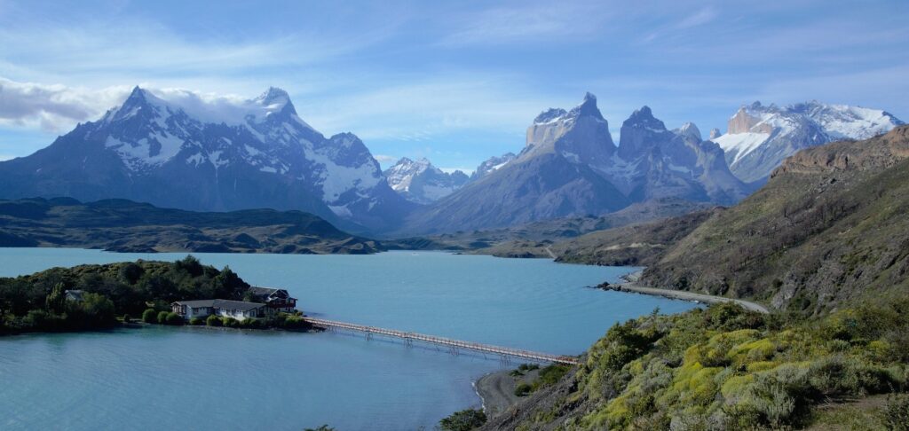
Chile is the country that geography drew as a line — 4,300 kilometres from the Atacama Desert in the north to Patagonia and Tierra del Fuego in the south, never more than 180 kilometres wide, containing within that improbable strip the driest place on earth, a wine country that the Andes shelter from Pacific moisture, a lake district of Germanic colonial towns and snowcapped volcanoes, and the Torres del Paine massif that represents Patagonian wilderness at its most compositionally perfect. Santiago is one of South America’s most liveable capitals. Easter Island is 3,700 kilometres out into the Pacific and operates on its own logic entirely. And at the southern tip of the continent, Punta Arenas and Ushuaia across the border serve as the departure points for what lies beyond — Antarctica. [Read the full Chile Travel Guide →]
Argentina runs the full register from the subtropical jungle of the northwest to the sub-Antarctic steppe of Patagonia — the Iguazú Falls on the Brazilian border delivering 275 individual cascades across a 2.7-kilometre front that makes Niagara feel preliminary, the Perito Moreno Glacier in Santa Cruz advancing at a rate audible from the viewing platforms, the wine country of Mendoza in the shadow of the Andes producing Malbecs that have redefined how the world understands South American viticulture. Buenos Aires is the city that tango built and European immigration furnished — the broad avenues, the bookshops that never close, the steakhouses operating on a schedule that begins where other cities’ evenings end, the specific melancholy of a great city that knows it has not yet become what it should be. [Read the full Argentina Travel Guide →]
Central America & The Atlantic Coast
Guatemala is the Maya civilisation’s most accessible living archive — the highland market town of Chichicastenango operating on a calendar and textile tradition that pre-dates the Spanish colonial period, the ruins of Tikal rising above the rainforest canopy in the Petén lowlands, and Lake Atitlán sitting in a volcanic caldera that Aldous Huxley called the most beautiful lake in the world, a claim that subsequent visitors have found difficult to dispute. Antigua’s colonial architecture, preserved by the UNESCO designation that followed the 1979 earthquake damage, completes a country of exceptional cultural density in a compact geography. [Read the full Guatemala Travel Guide →]
Belize is Central America’s only English-speaking country and its most concentrated biodiversity argument — the Mesoamerican Barrier Reef running the full length of its Caribbean coast as the second largest reef system in the world, the Blue Hole’s 300-metre submarine sinkhole achieving the specific shade of indigo that makes every aerial photograph of it look like a computer rendering, and the Maya sites of Caracol and Xunantunich in the western interior adding archaeological depth to an ecological proposition that needs no assistance. The country is small enough to cross in a day and varied enough to fill a month. [Read the full Belize Travel Guide →]
Costa Rica made an environmental bet in 1948 that no other country in the hemisphere matched — abolished its standing army, redirected the defence budget into education and conservation, and built an ecological infrastructure that now protects 26 percent of its national territory, the highest percentage of any country on earth. The cloud forests of Monteverde, the Arenal volcano and its geothermal hot springs, the Osa Peninsula’s Corcovado National Park — described by National Geographic as the most biologically intense place on earth — and the surf coast at Santa Teresa represent a country that turned its geographic constraints into a competitive advantage four decades before ecotourism became a category. [Read the full Costa Rica Travel Guide →]
Panama is the country that the world built a canal through, and that has spent the century since managing the tension between being a transit point and being a destination in its own right. The Canal is genuinely worth watching — the Miraflores Locks processing the ships that connect the Pacific and Atlantic with a mechanical efficiency that the 1914 engineers would recognise — but Panama City’s Casco Viejo, the Bocas del Toro archipelago on the Caribbean, the Chiriquí Highlands coffee country, and the Darién’s roadless wilderness make the case for the country beyond the infrastructure that defines its international identity. [Read the full Panama Travel Guide →]
Brazil is South America’s continental-scale argument — the fifth largest country in the world, the Amazon basin covering 60 percent of its territory in the largest tropical forest on earth, the coastline running 7,491 kilometres from the mouth of the Amazon to the southern border with Uruguay. Rio de Janeiro performs its particular drama daily — the Sugar Loaf, the Christ the Redeemer statue on Corcovado, the Copacabana and Ipanema beaches, the favela communities on the hillsides above it — with the specific self-awareness of a city that knows it is being watched. Salvador’s Afro-Brazilian culture, Iguazú on the Argentine border, Florianópolis’s southern coast, the Pantanal’s wetland wildlife, and Manaus as the Amazon’s improbable opera house complete a country that requires a second visit before it begins to make sense as a single entity. [Read the full Brazil Travel Guide →]
Uruguay is South America’s quiet proposition — the small country between Argentina and Brazil that decided on equality, secularism, and institutional stability rather than scale, and has spent two centuries being consistently underestimated as a result. Montevideo is the most liveable capital on the continent by most measured standards, the Ciudad Vieja’s 19th-century architecture and the Mercado del Puerto’s weekend parilla culture making a compact, walkable argument for the country’s specific quality of life. Colonia del Sacramento, the Atlantic beaches of Punta del Este, and the gaucho interior of the Pampas complete a country that rewards the traveller willing to slow down. [Read the full Uruguay Travel Guide →]
Antarctica: The Gateway at the End of the World
Antarctica is not a country. It is the last place — the continent that the Antarctic Treaty of 1959 designated as a territory dedicated to peace and science, removing it from national sovereignty in the most consequential act of collective geographic restraint in human history. No one owns it. No one permanently lives there. And yet it is reachable, and the approximately 50,000 visitors who make the crossing each year return with a consistent report: that nothing in their prior experience of travel prepared them for the scale, the silence, and the specific cognitive recalibration that comes from standing on a continent that humanity has not yet managed to ruin.
The gateway is the southern tip of South America. Ushuaia, in Argentina’s Tierra del Fuego, is the world’s southernmost city and the primary departure port for Antarctic expeditions. Punta Arenas in Chile is the secondary departure point, increasingly used for fly-cruise itineraries that skip the Drake Passage crossing and begin the expedition from King George Island. The Drake Passage — two to three days of open Southern Ocean between Cape Horn and the South Shetland Islands — is either the journey’s most demanding section or its most clarifying one, depending on the sea state and the traveller’s constitution.
The Antarctic Peninsula, accessible November through March when the sea ice retreats, delivers the full proposition: the blue-white cliff faces of tabular icebergs the size of office buildings, the leopard seals on ice floes, the penguin colonies at Neko Harbour and Paradise Bay operating at a density and indifference to human presence that renders every wildlife encounter from every other destination slightly less impressive in retrospect. The expedition cruise format — small ships of 100 to 200 passengers, Zodiac landings, naturalist guides — is not incidental to the experience. It is the experience. [Plan your Antarctica Expedition →]
When to Visit
South America’s geography spans the equator and extends to the sub-Antarctic, which means the seasonal logic runs in almost every direction simultaneously. The broad principle: the Southern Hemisphere summer of November through March is the operative peak for Patagonia, southern Chile and Argentina, and Antarctica. This is also the peak season for the Brazilian coast and the Iguazú Falls at their fullest. The Andean dry season of May through October is optimal for Peru, Bolivia, and the highland regions of Colombia and Ecuador — the period when the mountain passes are clear and the trekking routes are operational.
The Amazon operates on its own logic. The high-water season of December through May floods the forest and enables river navigation deep into the canopy; the low-water season of June through November concentrates wildlife on riverbanks and produces the better wildlife photography. Both are defensible choices for different reasons.
Central America runs a dry season of December through April across Guatemala, Costa Rica, Panama, and Belize — the period when the Pacific coast surf is consistent and the Maya ruins are not obscured by lowland humidity. The Caribbean coast of the same countries reverses the equation, with better conditions May through October. Costa Rica’s cloud forest is year-round, the rain being a feature rather than an inconvenience.
Antarctica operates within a strict window: November through March. November delivers the most dramatic wildlife behaviour — penguin courtship and nesting — while January and February provide the maximum daylight and the most navigable ice conditions. March is the last viable month before the sea ice closes the passage for the southern winter.
For the full seasonal breakdown, explore the monthly travel guides by destination.

Beyondia
Trusted Travel CompanionReal digital nomad. I travel. I learn. I grow.
What about you? Where are you going?