🌐 Around the World with Beyondia 🧵 Nordic & Western Europe Region 🪡 Episode 73: Lofoten
Lofoten is a Norwegian archipelago in Nordland county, extending approximately 160 kilometres from the mainland into the Norwegian Sea at approximately 68 degrees north latitude — well above the Arctic Circle (which crosses mainland Norway at approximately 66°33′N). The main islands are Austvågøya, Gimsøya, Vestvågøya, Flakstadøya, Moskenesøya, and Værøy and Røst further out to sea. The archipelago has approximately 24,500 residents distributed across specific towns and fishing villages, with the largest settlements being Svolvær (approximately 4,700 residents, the administrative centre), Leknes (approximately 3,600), and Kabelvåg (approximately 2,000). The population density is approximately 12 people per square kilometre — low by European standards but higher than the Westfjords covered at Ep 68 (0.3/km²) due to the concentrated fishing settlements along the coast.
Lofoten Geographical Specifics
The archipelago sits at the extreme northern latitude that produces the specific Arctic daylight cycle. Midsummer brings the true midnight sun — the sun does not set from approximately 26 May to 17 July at the latitude of Svolvær, providing approximately 53 days of continuous daylight. Midwinter brings polar night — the sun does not rise from approximately 7 December to 5 January, providing approximately 30 days without direct sunlight (though civil twilight provides some ambient light for a few hours around midday). The Northern Lights are visible from Lofoten between approximately mid-September and early April during clear nights, and Lofoten is one of the most reliable Northern Lights viewing locations on Earth due to its position within the auroral oval and its relatively frequent clear-sky periods.
Lofoten’s climate is milder than the extreme northern latitude would suggest, due to the North Atlantic Current (the northerly continuation of the Gulf Stream). Winter temperatures at Svolvær average approximately -1°C in January, roughly comparable to Oslo (approximately -4°C in January) despite being 900 kilometres further north. Summer temperatures average approximately 12°C in July. The specific climate combination — subarctic latitude with maritime moderation, dry cold winter winds ideal for fish drying, midnight sun in summer, polar night in winter — has shaped Lofoten’s specific character and its thousand-year fishery.
The geological character of Lofoten produces the dramatic landscape that defines contemporary visual conception of the archipelago. The islands are formed from some of the oldest rocks on Earth — Precambrian gneiss and granite dating back approximately 2.5 to 3.5 billion years, among the oldest surface rocks anywhere on the planet. These rocks were shaped by successive Ice Ages across the past 2.5 million years into the current landscape: sharp mountain peaks rising directly from the sea, deep glacial valleys, protected bays, and the specific “wall of mountains” that Lofoten presents when viewed from the sea. The highest peaks include Higravtinden (1,146 metres on Austvågøya), Møysalen (1,262 metres on Hinnøya at the archipelago’s eastern edge), and dozens of peaks between 800 and 1,100 metres. The specific quality of the Lofoten landscape — mountains rising abruptly from sea to over 1,000 metres, often within 1-2 kilometres of the coast — is one of the more distinctive coastal mountain landscapes in Europe.
Lofoten Early Viking Age
Norse settlement of Lofoten dates from at least the early Viking Age, and probably earlier. Archaeological evidence at Borg on Vestvågøya has revealed one of the largest Viking longhouses ever found — approximately 83 metres long, built around 500 AD and continuously occupied until approximately 950 AD, when the ruling family apparently emigrated (possibly to Iceland, as documented in the Landnámabók). The Borg longhouse indicates that Lofoten was an important Norse chieftaincy site during the pre-Viking and Viking periods, with substantial wealth and political importance. The Lofotr Viking Museum, opened at Borg in 1995, includes a full-scale reconstruction of the longhouse and provides one of the primary European sites for understanding Viking Age chieftaincy life.
The winter cod fishery — the skrei fishery — is documented in Norwegian written sources from the medieval period, but archaeological and biological evidence suggests it operated for centuries before the earliest written records. The Northeast Arctic cod (Gadus morhua morhua, locally called skrei) is a specific migratory subpopulation of Atlantic cod that lives in the Barents Sea for most of its life and migrates to Lofoten waters to spawn between January and April each year. The spawning migration is one of the largest annual fish migrations on Earth — historical estimates suggest peak migrations of over 1 billion individual fish, though contemporary stocks are smaller. The spawning grounds have been in the same Lofoten waters for approximately 8,000 years, since the Norwegian coast became ice-free after the last Ice Age, meaning the fishery has been available to human fishermen for as long as humans have inhabited the Norwegian coast.
Medieval Norwegian fishermen developed the specific tørrfisk (stockfish) production technique that transformed the seasonal cod migration into a globally traded commodity. Fresh cod, caught during the winter migration, is gutted, tied in pairs by the tail, and hung on wooden racks (hjell) to air-dry in the cold dry Arctic wind. The specific climate combination at Lofoten — winter temperatures consistently below freezing but not extremely cold, dry Arctic wind, low humidity — produces ideal conditions for the specific drying process. Fresh cod loses approximately 80% of its weight during the 2-3 month drying period, producing a light, dry, hard product that can be stored for years without refrigeration and transported over long distances without spoilage. Tørrfisk retains most of the nutritional value of fresh cod (particularly protein content, though vitamin content is reduced) and can be reconstituted by soaking in water or milk before cooking.
The tørrfisk trade became one of the foundations of medieval Norwegian economy from approximately the 12th century onwards. Bergen — established as a royal town in 1070 and covered in an upcoming article — became the primary export port, with tørrfisk from Lofoten and other northern Norwegian fisheries collected at Bergen and shipped to Catholic European markets. The specific demand driver was the medieval Catholic dietary calendar — approximately 150 days per year were designated as fasting days when meat consumption was prohibited, but fish was permitted. Tørrfisk from Lofoten became one of the primary protein sources for Catholic Europe during Lent and other fasting periods, particularly in inland regions distant from fresh fish supplies. Tørrfisk was traded to Germany, the Netherlands, England, France, Portugal, Spain, and Italy — one of the earliest examples of a globally traded processed food commodity.
The Hanseatic League — the medieval northern European trading confederation — established a major kontor (foreign trading office) at Bergen in 1360, and controlled much of the Norwegian tørrfisk export trade for approximately 400 years. German merchants at Bergen purchased tørrfisk from Norwegian fishermen (often through complex credit arrangements that kept fishermen indebted), and shipped it across the Hanseatic trade network to markets throughout northern Europe. The trade produced substantial wealth for the Hanseatic merchants, funded Bergen’s growth into one of medieval Scandinavia’s largest cities, and provided cash income to the Lofoten fishing communities. The specific commercial relationship — Lofoten as producer, Bergen as trading hub, Hanseatic League as distributor — shaped the economic geography of medieval Norway for approximately 500 years.
The tørrfisk trade continued through the early modern period, though the Hanseatic dominance ended by the 18th century. Norwegian and Danish merchants gradually took over the trade, and export markets shifted with European political and religious changes. The Reformation reduced tørrfisk demand in Protestant northern Europe (where fasting requirements were relaxed or eliminated), but Catholic markets in southern Europe remained strong. Portugal and Spain became particularly important tørrfisk markets, and Portuguese bacalhau — salted cod, a related but distinct product from tørrfisk — developed as one of the primary Portuguese national foods (as documented at Lisbon Ep 55 and Porto Ep 57). Italian markets, particularly Venice and Genoa, also maintained tørrfisk demand for the traditional baccalà preparations.
Contemporary Lofoten
Contemporary tørrfisk production at Lofoten remains approximately 90,000 tonnes annually — a substantial commercial fishery, though a fraction of the medieval peak. The traditional wooden drying racks (hjell) remain in use, and the specific drying process has changed relatively little since medieval times. Modern Lofoten fishermen use motorised boats and modern fishing equipment, but the fundamental cycle — winter cod migration, coastal fishing, air-drying on wooden racks — continues as it has for a millennium. The primary contemporary export markets are Italy (approximately 50% of exports, particularly to Vicenza and the Veneto region for the specific bacalao al vicentino dish), Portugal (approximately 20%), Spain, Croatia, and specific other Mediterranean markets. Tørrfisk from Lofoten received European Union PDO (Protected Designation of Origin) status in 2014 as “Tørrfisk fra Lofoten,” recognising the specific regional character of the product.
Beyond the fishery, contemporary Lofoten’s economic base includes tourism (approximately 1 million visitors annually, driven by the dramatic landscape, Northern Lights viewing, and the specific working-fishing-village character), aquaculture (salmon farming has developed in Lofoten waters, though with the same environmental controversies documented at Westfjords Ep 68), and small-scale manufacturing. The tourism sector has grown rapidly across the past 20 years, with specific concentration during the winter Northern Lights season (approximately January-March) and the summer midnight sun season (approximately June-July). The specific Lofoten villages — particularly Reine, Nusfjord, Henningsvær, and Å — have become photographed tourism destinations that appear regularly in international travel media.
Reine — the small fishing village of approximately 300 residents on Moskenesøya — has become one of the primary Lofoten tourism destinations. The village sits at the base of Reinebringen mountain (448 metres) which provides one of the most photographed viewpoints in Norway when climbed via the specific stone-step trail. Reine’s specific combination of red-painted rorbu (traditional fishermen’s cabins, many now converted to tourist accommodation), dramatic mountain backdrop, and functional fishing harbour provides the visual template that defines international conception of Lofoten. The specific rorbu architecture — small wooden buildings on stilts along the harbour, historically used as seasonal accommodation for fishermen from other regions during the winter cod fishery, painted red with white trim in the specific traditional Norwegian coastal style — has been substantially preserved.
Å (pronounced approximately “oh”) — the village at the southwestern tip of the archipelago, whose name means simply “small river” in Old Norse — is the end point of the E10 highway that runs through Lofoten from the mainland. The village has approximately 100 permanent residents and preserves one of the more coherent 19th-century Norwegian fishing village environments. The Norwegian Fishing Village Museum (Norsk Fiskeværsmuseum) at Å provides one of the primary museum treatments of traditional Lofoten fishing culture.
Henningsvær — the fishing village on small islands connected by bridges to Austvågøya — has approximately 500 permanent residents and one of the more concentrated working-fishing-village environments in Lofoten. The village’s specific football pitch, built on flat ground between mountains and sea, has become one of the internationally photographed Lofoten images. Henningsvær also hosts the Lofoten Krigsminnemuseum (War Memorial Museum) documenting the German occupation of Lofoten during World War II — including the specific 4 March 1941 British Combined Operations raid (Operation Claymore) that destroyed German fish oil facilities and captured German cipher equipment providing important intelligence for the broader Enigma decryption effort.
Nusfjord — the fishing village on Flakstadøya — is one of Norway’s best-preserved traditional fishing villages, protected as one of three national heritage sites under the Norwegian Nusfjord preservation project since 1975. The village has been continuously inhabited as a fishing station since the 9th century, has approximately 40 permanent residents today, and provides one of the more coherent preserved rorbu environments in Norway.
The Lofotr Viking Museum at Borg (opened 1995, expanded 2005) is one of the primary European Viking Age archaeological sites open to visitors. The reconstructed longhouse — approximately 83 metres long, built to full scale over the original archaeological site — provides one of the more complete experiences of Viking chieftaincy architecture available anywhere. The museum’s programming includes reconstructed Viking Age crafts, sailing programmes on reconstructed Viking ships, and specific research collaborations with international Viking studies institutions.
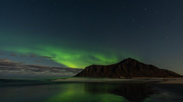
The Northern Lights viewing at Lofoten has become one of the primary tourism drivers of the past decade. Lofoten sits within the auroral oval — the ring-shaped region around the geomagnetic north pole where auroral activity is most concentrated — and has relatively frequent clear-sky periods during winter months compared to other Arctic regions. Viewing conditions are best between approximately mid-September and early April, with peak activity typically between November and February. The specific combination of dramatic mountain-and-sea landscape as visual foreground and reliable auroral display has made Lofoten one of the most-photographed Northern Lights locations in the world. The tourism industry has developed specific infrastructure around aurora tourism, including specific accommodation designed for aurora viewing, aurora forecasting services, and guided aurora photography tours.
The contemporary environmental and cultural pressures on Lofoten include the ongoing debate about offshore oil exploration. The specific Norwegian government has considered opening the Lofoten-Vesterålen-Senja offshore area to oil and gas exploration multiple times, and the specific area has been kept closed to petroleum activity primarily to protect the cod spawning grounds and the fishing industry. The environmental and fishing communities argue that petroleum activity would threaten the thousand-year fishery, while pro-exploration voices argue that offshore development would provide economic diversification. The specific debate has been one of the more contentious ongoing Norwegian environmental policy questions.
Housing pressure from tourism development is another ongoing concern. The conversion of traditional rorbu buildings to short-term tourist rentals has reduced permanent housing availability in specific Lofoten villages, and the specific tension between tourism revenue and community sustainability parallels debates in other European tourism destinations. Population trends are mixed — some villages continue slow decline (as documented across northern rural Norway generally), while others have stabilised or grown modestly due to tourism-related employment.
Lofoten is one of the demonstrations of how a specific geographical and climatic combination can produce a continuous economic activity across a thousand years. The Northeast Arctic cod migration to Lofoten waters has been happening for approximately 8,000 years. Norwegian fishermen have been catching the migration for at least a thousand years, probably longer. The tørrfisk production technique developed to preserve the winter catch has changed relatively little since medieval times. The specific commodity fed Catholic Europe through the medieval fasting periods, funded the Hanseatic League’s Bergen operations, and continues to be exported to Mediterranean markets today at approximately 90,000 tonnes annually. The specific villages that developed to support the fishery — Reine, Å, Nusfjord, Henningsvær, and dozens of others — preserve one of the more coherent traditional Norwegian rural architectural inheritances. The dramatic mountain-and-sea landscape shaped by 2.5 billion-year-old rocks and 2.5 million years of glacial action provides one of the more photographed European coastal environments. The Arctic latitude produces the specific paradox of midnight sun in summer and Northern Lights in winter that has made Lofoten one of the primary Arctic tourism destinations. And the specific working-fishery-plus-tourism combination continues to shape contemporary Lofoten identity — the wooden drying racks along the coast are not tourist heritage but functional infrastructure of a working fishery that has operated on the same annual cycle for a millennium.
Some places have been shaped by human activity over centuries. This one has been shaped by the same cyclical human activity — following the winter cod migration, air-drying the catch on wooden racks, exporting the preserved product to distant markets — for approximately a thousand years, in essentially the same locations, using essentially the same techniques. Some places above the Arctic Circle are remote outposts. This one has been a major node in European commodity trade since the 12th century. Some places with dramatic landscape are wilderness. This one is dramatic landscape and continuous working culture at the same time. Very few European regions carry this specific combination of extreme geography, thousand-year continuous economic activity, and contemporary tourism relevance.
Nine regions. One hundred and twenty destinations. Two hundred and eighty-eight weeks remaining.
The journey continues south along the Norwegian coast. The next stop is Norway’s second city and the historical destination for the tørrfisk from Lofoten — a Hanseatic League port on the western coast, home to seven mountains rising directly from the harbour, the Bryggen medieval wharf preserved as UNESCO World Heritage since 1979, one of the primary Norwegian fish markets, and the primary gateway to Norway’s southern fjord region.
Where are you going?

Beyondia
Trusted Travel CompanionReal digital nomad. I travel. I learn. I grow.
What about you? Where are you going?