🌐 Around the World with Beyondia 🧵 Nordic & Western Europe Region 🪡 Episode 75: Nordkapp
Nordkapp is a specific coastal promontory on the northern shore of Magerøya island in Troms og Finnmark county, Norway. The specific cliff rises 307 metres directly from the Barents Sea, presenting one of the most dramatic Arctic coastal geographies in Europe. The specific coordinates are 71°10′21″N latitude, 25°47′40″E longitude — placing Nordkapp well above the Arctic Circle (66°33′N) and approximately 2,100 kilometres from the geographic North Pole. The specific cape is administratively part of Nordkapp municipality, which has approximately 3,000 residents distributed primarily in the specific fishing town of Honningsvåg (approximately 2,400 residents, the municipal centre) approximately 34 kilometres south of the cape.
Nordkapp Northern Lights
The specific latitude produces the extreme Arctic daylight cycle. Midsummer brings continuous midnight sun from approximately 14 May to 29 July — 76 days when the sun does not set below the horizon. Midwinter brings polar night from approximately 20 November to 22 January — 63 days when the sun does not rise above the horizon (though civil twilight provides some ambient light for 2-3 hours around midday during the shortest weeks). The specific Northern Lights are visible from Nordkapp between approximately mid-September and early April, though the specific coastal position and frequent cloud cover reduce viewing reliability compared to inland Arctic locations like Alta (documented at Ep 74).
The specific climate at Nordkapp is oceanic Arctic, moderated by the North Atlantic Current (the northern continuation of the Gulf Stream that provides similar climatic moderation across all of coastal Arctic Norway, as documented at Lofoten Ep 73). Winter temperatures average approximately -4°C in January (mild for the extreme northern latitude), with cold snaps occasionally reaching -20°C during specific weather patterns. Summer temperatures average approximately 8°C in July, with peak days rarely exceeding 15°C. The specific weather at the cape itself is often severe — strong winds, fog, and horizontal rain are common, and visitors are frequently disappointed when the specific midnight sun or Northern Lights are obscured by weather. Approximately 60% of visits during peak tourist season occur under weather conditions that provide only partial views of the specific Arctic Ocean panorama that the site markets.
Nordkapp Geological Character
The geological character of Nordkapp — and the specific reason for the dramatic 307-metre cliff geometry — is Devonian sandstone dating to approximately 400 million years ago. The specific rocks were deposited as sediments during the Devonian period when the region was near the equator, subsequently transported to the Arctic by continental drift across approximately 400 million years of tectonic movement, and shaped into the specific current cliff geometry by successive Ice Ages across the past 2.5 million years. The specific glacial action produced the fjord and mountain landscape of Magerøya island, with the specific Nordkapp cliff representing the specific northern edge of the eroded plateau.
Human presence in the Magerøya region dates from at least 10,000-11,000 years ago, following the post-glacial ice retreat that opened the Arctic coast to human migration. The specific archaeological record includes coastal settlement sites and specific hunting sites documenting continuous occupation across approximately 12,000 years, similar to the pattern documented at Alta Ep 74. The specific Sámi population traditionally used the Nordkapp region for seasonal reindeer herding and coastal fishing, and specific Sámi place names remain in use across Magerøya. The specific Sámi name for Nordkapp is Davvenjárga.
Norse settlement of Magerøya dates from approximately the Viking Age, with the specific fishing settlement at Sarnes (near the modern Honningsvåg) documented from approximately the 9th century AD. Medieval and early modern Norse-Norwegian occupation focused on the specific cod fisheries that developed across Arctic Norway (as documented at Lofoten Ep 73), with Magerøya serving as one of the specific summer fishing bases for fishermen from further south. The specific island remained thinly populated through the medieval and early modern periods, with permanent population probably below 200 residents until the 19th century when the specific commercial fisheries expansion drove population growth.
The specific documented European visitor history at Nordkapp begins with Richard Chancellor’s 1553 English expedition. Chancellor was the specific navigator and captain of the Edward Bonaventure, one of three ships sent by the Muscovy Company from London in May 1553 under the command of Sir Hugh Willoughby to attempt the specific Northeast Passage to China around the northern Norwegian and Russian coasts. The specific expedition was one of the earliest systematic English attempts to find an Arctic route to Asia, motivated by the specific commercial competition with Spanish and Portuguese trade routes to the East Indies via the Cape of Good Hope. The three ships became separated in a specific storm off the Norwegian coast in August 1553. Willoughby’s two ships continued east and became trapped in ice at the mouth of the Varzina River on the Kola Peninsula, where the specific crew perished during the winter of 1553-1554 (their bodies and log books were discovered by Russian fishermen in 1554). Chancellor’s ship rounded the specific cape on Magerøya and named it “the North Cape” (in the earliest documented use of the name), before continuing east to reach the White Sea port of Arkhangelsk (then called Nikolo-Korelsky) in August 1553. From Arkhangelsk, Chancellor traveled overland to Moscow, met with Ivan the Terrible, and negotiated the specific first English commercial treaty with Russia — establishing the Muscovy Company’s specific 200-year monopoly on Anglo-Russian trade.
The specific Chancellor expedition established Nordkapp as one of the earliest named Arctic tourism destinations in European geographical consciousness. The specific name “North Cape” spread through European cartography and maritime literature over the following centuries. Individual travelers and specific scientific expeditions visited across the 16th-18th centuries, including the specific 1664 visit of Italian priest Francesco Negri (who is credited with the earliest documented tourism visit to the cape, arriving via a specific overland-then-boat journey from Bergen). Louis-Philippe of France (later King Louis-Philippe I) visited the cape in 1795 during his specific exile period. Various English and German scientific expeditions visited across the 19th century.
The specific event that transformed Nordkapp from occasional destination into mass tourism site was King Oscar II of Sweden and Norway’s visit on 2 July 1873. Oscar II — who reigned over the specific Swedish-Norwegian union from 1872-1905 — made a specific royal visit to the cape as part of a broader Arctic tour, arriving via steamship and climbing the specific 307-metre cliff via the ropes and ladders that were the only access route at the time. The specific royal visit was extensively documented in Scandinavian and European press, and the specific engraving of King Oscar II standing on the cape became one of the widely reproduced images of Arctic Norway across the late 19th century. The specific royal visit generated a specific tourism boom — visitor numbers grew from approximately 100 per year before 1873 to several thousand per year by 1900.
The specific tourism infrastructure development at Nordkapp began substantively in the late 19th century. A specific stone shelter was constructed at the cape in 1874 (the year after Oscar II’s visit) to provide basic shelter for visitors. Regular steamship service to the cape began in the 1880s, with visitors landing at the specific harbour of Skarsvåg on the eastern coast of Magerøya, then hiking or riding horses across the specific mountain plateau to reach the cliff. The specific first road to the cape was constructed in 1956, replacing the traditional hiking approach with vehicle access. The specific Nordkapptunnelen undersea tunnel connecting Magerøya to the mainland opened 15 June 1999 (approximately 6.8 kilometres long, one of the longest undersea road tunnels in Norway), providing year-round road access. Prior to the tunnel opening, Magerøya was accessible only by ferry or (in winter) by specific ice-road service across the Magerøysundet strait.
The specific Nordkapphallen visitor centre was constructed in stages beginning in 1959, with major expansions in 1978 and 1988, and further modernisation continuing to the present. The specific centre includes the panoramic viewing hall built into the cliff itself, a 225-seat cinema showing specific Arctic wilderness films, restaurants, exhibition spaces documenting the specific expedition history and Arctic geography, a chapel used for weddings (Nordkapp is one of the more popular specific “extreme location” wedding sites in Europe), and the specific “Grotten” underground grotto reaching approximately 50 metres below the cliff surface. The specific Globe Monument on the plateau — a specific 6-metre steel sphere marking the specific cliff edge, erected in 1978 — has become one of the most-photographed Norwegian monuments.
Contemporary Nordkapp
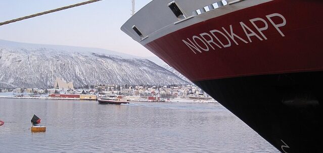
Contemporary Nordkapp tourism represents approximately 250,000-300,000 annual visitors, with substantial specific concentration during the June-August peak season when midnight sun visibility is best. The specific visitor demographics have shifted substantially over the past 30 years — from primarily Scandinavian and German visitors before approximately 1995 to increasingly international composition today, with substantial specific growth in East Asian (particularly Chinese and Japanese), American, and southern European visitor numbers. The specific tourism model combines individual travelers (arriving via rental car through the tunnel), organized bus tours (from Alta, Tromsø, and specific other Arctic urban centres), and cruise ship tourism (with cruise ships anchoring at Honningsvåg and busing passengers to the cape). The specific Hurtigruten coastal steamer service (documented at Trondheim Ep 72) stops at Honningsvåg, providing traditional Norwegian coastal cruise access.
The specific pricing structure at Nordkapp has been controversial in Norwegian public debate. The specific entrance fee to the Nordkapphallen visitor centre and access to the cape itself was 285 Norwegian kroner (approximately €25) per adult in 2024 — one of the more expensive tourist entrance fees in Norway. The specific fees generated approximately 100 million Norwegian kroner (approximately €9 million) in annual revenue, with substantial portions going to Rica Hotels (the specific private company that operates the Nordkapphallen visitor centre under contract from the Norwegian state). The specific arrangement has been criticised as commercial exploitation of a natural site, and the Norwegian Constitutional Court ruled in 2018 that the specific requirement to pay an entrance fee to access the natural landscape violated Norwegian right-to-roam laws (allemannsretten). Subsequent policy changes have provided free access to the natural landscape while maintaining paid access to the visitor centre buildings and infrastructure — a specific compromise that continues to generate ongoing debate.
Beyond the specific cape itself, Magerøya island includes specific additional Arctic tourism attractions. Knivskjellodden — the actual northernmost point of Magerøya island, approximately 1,500 metres further north than the Nordkapp cliff (71°11′08″N versus 71°10′21″N) — is accessible via a specific 9-kilometre hiking trail from a parking area on the E69 highway, providing a specific 4-6 hour round-trip hike that reaches the actual northernmost point of the island (though this too is not mainland Europe’s northernmost point). The specific hike passes through Arctic tundra landscape, with reasonable probability of specific reindeer sightings and specific bird observation opportunities. Approximately 8,000-12,000 hikers complete the specific Knivskjellodden route annually — a small fraction of the Nordkapp visitor numbers but representing the specific “authentic” northern-point experience for visitors who value the correction over the marketing.
The specific Nordkinn peninsula — containing Kinnarodden, the actual northernmost point of mainland Europe (71°8′1″N) — is accessible only via specific extended hiking routes from Mehamn (approximately 40 kilometres one-way) or via boat charter, with no road access to the specific cape itself. Approximately 200-500 hikers complete the specific Kinnarodden route annually, making it one of the more specific “expedition-style” hiking destinations in Norway. The specific factual distinction — Kinnarodden as the actual mainland Europe northernmost point, versus Nordkapp as the marketed but factually incorrect claim — remains substantially unknown to the majority of Arctic tourism visitors.
Honningsvåg — the specific fishing town on Magerøya where most Nordkapp visitors are based — has approximately 2,400 residents and functions as the specific commercial and administrative centre of Nordkapp municipality. The specific town was substantially destroyed during the specific German scorched-earth retreat from Finnmark in October-November 1944 (the specific Wehrmacht destroyed approximately 25,000 buildings across Finnmark and northern Troms during the specific retreat from the advancing Soviet Red Army, one of the specific late-war atrocities that affected essentially all Finnmark communities). Honningsvåg was rebuilt in the specific post-war period as one of the specific Norwegian reconstruction projects. The specific Honningsvåg Church (Honningsvåg kirke) is the specific oldest surviving building on Magerøya — it survived the German destruction due to its use as a specific German military supply depot, and dates from 1885. The specific Honningsvåg contemporary infrastructure includes the specific Nordkappmuseet (Nordkapp Museum) documenting local fishing history and Nordkapp tourism history, the specific Honningsvåg Airport (with regular flights to Tromsø), the specific fishing harbour, and specific commercial and residential districts.
The specific contemporary economic base of Nordkapp municipality includes tourism (approximately 60% of local employment relates to tourism directly or indirectly), commercial fishing (particularly cod and specific Arctic species), and specific public sector employment (regional administration, education, healthcare). The specific tourism sector shows the ongoing tensions common across European Arctic tourism destinations — rapid growth producing infrastructure pressure, seasonal employment patterns creating specific economic instability outside peak season, and the specific balancing of tourism revenue with community sustainability that parallels debates documented at Westfjords Ep 68, Lofoten Ep 73, and Alta Ep 74.
Nordkapp is one of the demonstrations of how tourism marketing can shape geographical understanding across generations, even when the specific marketing claim is factually incorrect. The specific “mainland Europe’s northernmost point” claim has been used consistently in Nordkapp tourism marketing since the late 19th century, despite the specific factual reality that Nordkapp is neither on the mainland (Magerøya is an island, connected to the mainland by undersea tunnel since 1999 but nonetheless an island) nor the northernmost point of its own island (Knivskjellodden is 1,500 metres further north). The actual northernmost point of mainland Europe is Kinnarodden on the Nordkinn peninsula, accessible only by boat or extended hiking with no road access. The specific factual complexity does not diminish Nordkapp’s substantive significance — the cape has been visited by European travelers since Richard Chancellor’s 1553 expedition, became a mass tourism destination after King Oscar II’s 1873 royal visit, and continues to attract approximately 250,000-300,000 annual visitors to the specific 307-metre Arctic cliff. But the specific factual correction matters because it distinguishes what Nordkapp actually is (one of Europe’s most-marketed Arctic destinations with 470 years of documented visitor history and a specific dramatic Arctic landscape) from what tourism marketing claims it to be (a geographical distinction that belongs to Kinnarodden). The “never give fake information” principle applied to travel writing means naming the correction, even for the most-marketed destination in Arctic Norway.
Some destinations are exactly what tourism marketing claims. This one is not — the specific “mainland Europe’s northernmost point” claim is factually incorrect, and has been for the specific 400 years since Richard Chancellor named the cape in 1553. Some Arctic sites are peripheral outposts. This one has 470 years of documented visitor history, mass tourism since 1873, and approximately 300,000 annual visitors. Some places are worth visiting despite the marketing rather than because of it. This one falls into that category — a genuinely dramatic Arctic cliff with substantive historical, geographical, and cultural significance, accessible via specific well-developed tourism infrastructure, that happens not to be what the marketing consistently claims. Very few European tourism destinations carry this specific combination of substantive significance and factual marketing inaccuracy across so long a documented history.
Nine regions. One hundred and twenty destinations.
Where are you going?

Beyondia
Trusted Travel CompanionReal digital nomad. I travel. I learn. I grow.
What about you? Where are you going?